
Havrå: Difference between revisions
image |
m Replaced id values with Wikidata items from external link templates | Userscript |
||
| (39 intermediate revisions by 23 users not shown) | |||
| Line 1: | Line 1: | ||
{{Infobox settlement |
|||
__NOTOC__ |
|||
|official_name = Havrå |
|||
[[Image:Havre01.jpg|thumb|Havretunet]] |
|||
|other_name = Havre |
|||
| ⚫ | '''Havrå''' or '''Havre''' sometimes '''Havretunet''' or '''Havråtunet''' is a cluster of |
||
|native_name = |
|||
|nickname = |
|||
|settlement_type = Farm |
|||
|image_skyline = Havre01.jpg |
|||
|image_caption = View of the farm area, Havretunet |
|||
|pushpin_map = Vestland |
|||
|pushpin_label_position = left |
|||
|pushpin_mapsize = |
|||
|pushpin_map_caption = Location in [[Vestland]] county |
|||
|subdivision_type = Country |
|||
|subdivision_name = [[Norway]] |
|||
|subdivision_type1 = [[List of regions of Norway|Region]] |
|||
|subdivision_name1 = [[Western Norway]] |
|||
|subdivision_type2 = [[Counties of Norway|County]] |
|||
|subdivision_name2 = [[Vestland]] |
|||
|subdivision_type3 = [[Districts of Norway|District]] |
|||
|subdivision_name3 = [[Nordhordland]] |
|||
|subdivision_type4 = [[List of municipalities of Norway|Municipality]] |
|||
|subdivision_name4 = [[Osterøy]] |
|||
|timezone1 = [[Central European Time|CET]] |
|||
|utc_offset1 = +01:00 |
|||
|timezone1_DST = [[Central European Summer Time|CEST]] |
|||
|utc_offset1_DST = +02:00 |
|||
|elevation_m = 71 |
|||
|elevation_footnotes = <ref>{{cite web|url=http://www.yr.no/place/Norway/Vestland/Oster%C3%B8y/Havr%C3%A5~2271136/|title=Havrå|publisher=[[yr.no]]|language=Norwegian|accessdate=2014-04-25}}</ref> |
|||
|coordinates = {{coord|60|26|22|N|05|34|31|E|type:city|display=inline,title}} |
|||
}} |
|||
| ⚫ | '''Havrå''' or '''Havre''' (sometimes '''Havretunet''' or '''Havråtunet''') is a [[cluster farm]] along the southern shore of the island of [[Osterøy (island)|Osterøy]] in [[Osterøy]] [[Municipalities of Norway|municipality]], [[Vestland]] county, [[Norway]]. Havrå is one of the last and best preserved of the common farm clusters on the western coast of Norway. Havrå was the first cultural environment to be protected under section 20 of the [[Cultural Heritage Act (Norway)|Norwegian Cultural Heritage Act]].<ref name=":0">{{Cite news|url=http://kulturarv.no/en/node/471|title=Havrå Farmstead|date=2003-03-06|newspaper=Norwegian Cultural Heritage|language=nb|access-date=2016-12-05}}</ref> It was not connected to the national road network until late in the 1960s. |
||
| ⚫ | |||
| ⚫ | Havrå is situated on very steep terrain on the south side of the island of [[Osterøy (island)|Osterøy]], along the [[Sørfjorden (Osterøy)|Sørfjorden]]. The farm area is shaped in a typical fashion for the steep terrain along the Western Norwegian [[fjord]]s. It can be clearly seen from both the railway (the [[Bergen Line]]) and the highway that goes between the cities of [[Bergen]] and [[Oslo]]. |
||
| ⚫ | |||
| ⚫ | |||
| ⚫ | |||
== History of names == |
|||
| ⚫ | |||
| ⚫ | The name, with various spellings, dates back as far as 1303. In the oldest sources the name is written Havra (possibly representing Havrá). From the 16th century the name was often spelled (with many variations) Havre. |
||
==Name== |
|||
| ⚫ | In |
||
| ⚫ | The name, with various spellings, dates back as far as 1303. In the oldest sources the name is written Havra (possibly representing Havrá). From the 16th century the name was often spelled (with many variations) Havre.<ref>{{cite web|url=http://kulturnett.ivest.no/tema/havraa/historie.htm|title=Brief history of Havråtunet|publisher=Stiftinga Havråtunet|language=Norwegian|url-status=dead|archiveurl=https://web.archive.org/web/20070116223148/http://kulturnett.ivest.no/tema/havraa/historie.htm|archivedate=2007-01-16}}</ref> |
||
| ⚫ | In 1949–1950, a film called ''Havretunet'' was made about life at Havrå. It was released in 1952. Some of the people taking part in the film worked to change the name from Havre to Havrå. This changing of name was accepted by the National Map Service, but the name change remains controversial among the local population.<ref>{{cite web|url=http://privat.bluezone.no/havre/03MH230597.htm|title=Havre or Havrå?|language=Norwegian|url-status=dead|archiveurl=https://web.archive.org/web/20110716132230/http://privat.bluezone.no/havre/03MH230597.htm|archivedate=2011-07-16}}</ref><ref>{{cite web|url=http://privat.bluezone.no/havre|title=Havre is the name|language=Norwegian|url-status=dead|archiveurl=https://web.archive.org/web/20110724174530/http://privat.bluezone.no/havre/|archivedate=2011-07-24}}</ref> |
||
==Gallery== |
|||
== Part of The Museum Centre in Hordaland == |
|||
The farm is now a part of the museum organisation The Museum Centre in Hordaland, together with [[Osterøy museum]], [[The Heathland Centre]] at [[Lygra]] and The Western Norway Emigration Centre at [[Radøy (island)|Radøy]], and [[The Textile Industry Museum]], The Conservation Department, The Cultural Heritage Service in Nordhordland, and the museum administration in Salhus. |
|||
==Media gallery== |
|||
<gallery> |
<gallery> |
||
File:Havråtunet mot Romslo.jpg|View looking south towards the mainland |
|||
| ⚫ | |||
File:Havre04.jpg|Havretunet between the houses |
|||
| ⚫ | |||
| ⚫ | |||
File:Havre09.jpg|A demanding technique, but the cladding lasts for 30–50 years |
|||
File:Havre10.jpg| [[water mill]] |
|||
| ⚫ | |||
| ⚫ | |||
| ⚫ | |||
| ⚫ | |||
| ⚫ | |||
| ⚫ | |||
| ⚫ | |||
File:Havråtunet i Sørfjorden.jpg|View of the traditional fencing |
|||
File:Havråtunet - kvernhusrekke.jpg|Mill houses |
|||
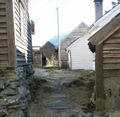
File:Havråtunet - midtre gate.jpg|Main path through the farm area |
|||
</gallery> |
</gallery> |
||
== |
==See also== |
||
| ⚫ | |||
== See also == |
|||
* [[Strip farming in Norway]] |
* [[Strip farming in Norway]] |
||
*movie "Two Lives" (2012) - scenes filmed at Havra farm |
|||
==References== |
|||
| ⚫ | |||
| ⚫ | |||
| ⚫ | |||
| ⚫ | |||
| ⚫ | |||
| ⚫ | |||
*[https://muho.no/havra/en Website] |
|||
| ⚫ | |||
| ⚫ | |||
* [http://www.sffarkiv.no/sffbasar/style_hordaland.asp?p=result&db=dbatlas_leks&art_id=110829&spraak_id=1&ptype=single Kulturnett Hordaland] |
|||
| ⚫ | |||
* [http://museumsnett.no/salhus/havratunet.htm Stiftinga Havråtunet] |
|||
| ⚫ | |||
| ⚫ | |||
* [http://www.muho.no Museumssenteret i Hordaland] |
* [http://www.muho.no Museumssenteret i Hordaland] |
||
* [http://www.miljostatus.no/Tema/Kulturminner/Kulturmiljoer/Fredete-kulturmiljoer/Havra/ Miljøstatus i Norge: Havrå] |
* [https://archive.today/20130112053137/http://www.miljostatus.no/Tema/Kulturminner/Kulturmiljoer/Fredete-kulturmiljoer/Havra/ Miljøstatus i Norge: Havrå] |
||
{{authority control}} |
|||
{{coord|60|26|N|5|34|E|display=title|region:NO_type:city_source:GNS-enwiki}} |
|||
{{DEFAULTSORT:Havraa}} |
|||
[[Category:Populated places in |
[[Category:Populated places in Vestland]] |
||
[[Category:Historic farms in Norway]] |
[[Category:Historic farms in Norway]] |
||
[[Category:Farms in Vestland]] |
|||
[[Category:Osterøy]] |
[[Category:Osterøy]] |
||
[[no:Havretunet]] |
|||
[[nn:Havråtunet]] |
|||
Latest revision as of 18:22, 5 December 2023
Havrå
Havre | |
|---|---|
Farm | |
 View of the farm area, Havretunet | |
 Havrå Location in Vestland county | |
| Coordinates: 60°26′22″N 05°34′31″E / 60.43944°N 5.57528°E | |
| Country | Norway |
| Region | Western Norway |
| County | Vestland |
| District | Nordhordland |
| Municipality | Osterøy |
| Elevation | 71 m (233 ft) |
| Time zone | UTC+01:00 (CET) |
| • Summer (DST) | UTC+02:00 (CEST) |
Havrå or Havre (sometimes Havretunet or Havråtunet) is a cluster farm along the southern shore of the island of Osterøy in Osterøy municipality, Vestland county, Norway. Havrå is one of the last and best preserved of the common farm clusters on the western coast of Norway. Havrå was the first cultural environment to be protected under section 20 of the Norwegian Cultural Heritage Act.[2] It was not connected to the national road network until late in the 1960s.
Havrå is situated on very steep terrain on the south side of the island of Osterøy, along the Sørfjorden. The farm area is shaped in a typical fashion for the steep terrain along the Western Norwegian fjords. It can be clearly seen from both the railway (the Bergen Line) and the highway that goes between the cities of Bergen and Oslo.

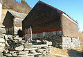
Many of the buildings at Havrå are characteristic to the inner coastal district between Bergen and the Sognefjorden; the combination of dry masonry and juniper cladding on barn façades that are exposed to rain and wind.[2]
Name[edit]
The name, with various spellings, dates back as far as 1303. In the oldest sources the name is written Havra (possibly representing Havrá). From the 16th century the name was often spelled (with many variations) Havre.[3]
In 1949–1950, a film called Havretunet was made about life at Havrå. It was released in 1952. Some of the people taking part in the film worked to change the name from Havre to Havrå. This changing of name was accepted by the National Map Service, but the name change remains controversial among the local population.[4][5]
Part of The Museum Centre in Hordaland[edit]
The farm is now a part of the museum organisation The Museum Centre in Hordaland, together with Osterøy museum, The Heathland Centre at Lygra and The Western Norway Emigration Centre at Radøy, and The Textile Industry Museum, The Conservation Department, The Cultural Heritage Service in Nordhordland, and the museum administration in Salhus.
Media gallery[edit]
-
 View looking south towards the mainland
 -
 Havretunet between the houses
 -
 Havretunet between the houses
 -
 A demanding technique, but the cladding lasts for 30–50 years
 -
-
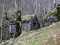
 The mills are near the houses
 -
 Havretunet from across Sørfjord, near Romslo
 -
 The grain is poured into the tract and the flavour is gathered on the desktop surrounding millstones and is wiped down to a bin in the front of the table
 -
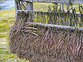
 Weather exposed barn walls clad with juniper. Juniper keeps the lashing rain out, permits draft and keeps the hay dry.
 -
 View of the traditional fencing
 -
 Mill houses
 -
 Main path through the farm area


See also[edit]
- Strip farming in Norway
- movie "Two Lives" (2012) - scenes filmed at Havra farm
References[edit]
- ^ "Havrå" (in Norwegian). yr.no. Retrieved 2014-04-25.
- ^ a b "Havrå Farmstead". Norwegian Cultural Heritage (in Norwegian Bokmål). 2003-03-06. Retrieved 2016-12-05.
- ^ "Brief history of Havråtunet" (in Norwegian). Stiftinga Havråtunet. Archived from the original on 2007-01-16.
- ^ "Havre or Havrå?" (in Norwegian). Archived from the original on 2011-07-16.
- ^ "Havre is the name" (in Norwegian). Archived from the original on 2011-07-24.
External links[edit]
- Website
- Stiftinga Havråtunet (in Norwegian)
- Introduction to the documentary film about Havretunet (in Norwegian)
- Havretunet at IMDb
- Havråtunet at IMDb Short version of the original documentary film Havretunet
- Museumssenteret i Hordaland
- Miljøstatus i Norge: Havrå