
Neeritter
Neeritter | |
|---|---|
Village | |
 St Lambertus Church | |
 Coat of arms | |
 Neeritter Location in the Netherlands  Neeritter Location in the province of Limburg in the Netherlands | |
| Coordinates: 51°09′55″N 5°48′10″E / 51.16528°N 5.80278°E | |
| Country | Netherlands |
| Province | Limburg |
| Municipality | Leudal |
| Area | |
| • Total | 4.23 km2 (1.63 sq mi) |
| Elevation | 29 m (95 ft) |
| Population (2021)[1] | |
| • Total | 1,275 |
| • Density | 300/km2 (780/sq mi) |
| Time zone | UTC+1 (CET) |
| • Summer (DST) | UTC+2 (CEST) |
| Postal code | 6015[1] |
| Dialing code | 0475 |
Neeritter is a village in the Dutch province of Limburg. It is located in the municipality of Leudal.
History[edit]
The village was first mentioned in 1143 as "aliam Iteram que dicitur nova", and means "lower lying stream".[3]
Neeritter developed in the Early Middle Ages along the Itterbeek.[4] In 1584, a semi circular wall was built around the village to protect against the plundering armies during the Eighty Year's War.[5] Between 1614 and 1795, it was part of the Prince-Bishopric of Liège. In 1839, the border between Netherlands and Belgium was defined, and the Borgitter Castle ended up in Kessenich, Belgium.[4]
The Catholic St Lambertus Church is a three aisled church which has 13th century elements. The tower was enlarged in 1842.[4]
The Armenmolen is watermill. A watermill has been known to exist at the site since 1280. The current mill was built between 1684 and 1687. It went out of service in 1950, and is a residential home since 1972. The water wheel was replaced in 1997.[6]
Neeritter was home to 656 people in 1840.[5] Neeritter was a separate municipality until 1942, when it was merged with Hunsel.[7] In 2007, it became part of the municipality of Leudal.[5]
Gallery[edit]
-
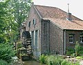 Water mill Armenmolen
 -
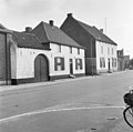 Street view
 -
 Street view


References[edit]
- ^ a b c "Kerncijfers wijken en buurten 2021". Central Bureau of Statistics. Retrieved 24 April 2022.
- ^ "Postcodetool for 6015AA". Actueel Hoogtebestand Nederland (in Dutch). Het Waterschapshuis. Retrieved 24 April 2022.
- ^ "Neeritter - (geografische naam)". Etymologiebank (in Dutch). Retrieved 24 April 2022.
- ^ a b c Sabine Broekhoven, & Ronald Stenvert (2003). Neeritter (in Dutch). Zwolle: Waanders. ISBN 90 400 9623 6. Retrieved 24 April 2022.
- ^ a b c "Neeritter". Plaatsengids (in Dutch). Retrieved 24 April 2022.
- ^ "Armenmolen Neeritter". Kempenbroek molens (in Dutch). Retrieved 24 April 2022.
- ^ Ad van der Meer and Onno Boonstra, Repertorium van Nederlandse gemeenten, KNAW, 2011.
| International | |
|---|---|
| National | |
| Geographic | |