Ravensden
| Ravensden | |
|---|---|
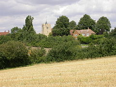
 All Saints Church at Ravensden. | |
Location within Bedfordshire | |
| Population | 1,961 (2011 Census)[1] |
| OS grid reference | TL076705 |
| Unitary authority | |
| Ceremonial county | |
| Region | |
| Country | England |
| Sovereign state | United Kingdom |
| Post town | BEDFORD |
| Postcode district | MK44 |
| Dialling code | 01234 |
| Police | Bedfordshire |
| Fire | Bedfordshire and Luton |
| Ambulance | East of England |
| UK Parliament | |
Ravensden is a village and civil parish located in the Borough of Bedford in Bedfordshire, England.
The parish borders the town of Bedford, with Mowsbury Park and farmland acting as a buffer between the two settlements. The village hosts Ravensden Lower School, and a pub called The Horse and Jockey, as well as All Saints Church. There is also a village hall.
For elections to Bedford Borough Council, Ravensden is part of Great Barford ward. A housing estate called Woodlands Park was established in the southern part of Ravensden parish in the late 2000s. The estate is separated from the village by farmland, with vehicular access to the community coming from the Brickhill area of Bedford. In April 2015 Woodlands Park became part of Brickhill parish, but remains part of Great Barford ward for elections to Bedford Borough Council.
References
- ^ "Civil Parish population 2011". Office for National Statistics. Retrieved 11 November 2016.
External links

