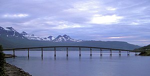
Årsteinbrua
Coordinates: 68 ° 41 ′ 10 ″ N , 17 ° 32 ′ 53 ″ E
| Årsteinbrua | ||
|---|---|---|
| Årsteinbrua | ||
| use | Road traffic | |
| Convicted | Fylkesvei 141 | |
| Crossing of | Gratangen | |
| place | Årstein , Norway | |
| construction | Cantilever bridge | |
| overall length | 396 m | |
| location | ||
|
|
||
| Above sea level | 0 m | |
The Årsteinbrua ( Årsteinbrücke ) is a 396 m long as a cantilever bridge with a total of 13 pillars built road bridge in the municipality Gratangen in the Norwegian Fylke (Province) Finnmark Troms og .
It carries the provincial road Fv 141 over the Gratangen at its narrowest point between Strømsnes / Straumsnes on the south bank, where the Fv 141 branches off the Fv 825 , which comes from the southeast and European route 6 , and Årstein , the administrative center and the largest town with around 200 inhabitants Commune, on the north bank. At this point the fjord is less than 10 m deep and merges into its 6 km long inner fjord, the Gratangsbotn.
Web links
Commons : Årsteinbrua - collection of images, videos and audio files


