Île des Impressionnistes
| Île des Impressionnistes | ||
|---|---|---|
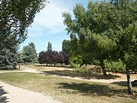
| View over the Seine from the Park of the Impressionists | ||
| Waters | His | |
| Geographical location | 48 ° 53 '3 " N , 2 ° 9' 40" E | |
|
|
||
| length | 900 m | |
| width | 300 m | |
The île des Impressionnistes is an inland island of the Seine . It is located about 10 km west of Paris in the middle of the city of Chatou . Your name comes from the many painters of Impressionism ago that frequented the island often.
The 4.5 km long river island , which belongs to the Yvelines department and is typical of the Seine, is connected to the Île fleurie to the north (upstream) and to the Île de la Chaussée to the south by dams that were built in the 18th century. The total length of the three islands connected by dams is 8.5 km.
By connecting the islands, Marly's machine , which is located near the île des Impressionnistes, could be operated more efficiently. The majority of the island is now owned by the energy company EDF, which has maintained several research facilities here since the end of the Second World War . The Impressionist Park was created for visitors and the Maison Fournaise restaurant, which closed in 1906 and was very popular with Impressionist painters, reopened as a museum with an adjoining restaurant.
The RER A railway line and the national route 186 run across the island .


