Šarengradska Ada
| Šarengradska Ada | ||
|---|---|---|
| Location of the river island Šarengradska Ada | ||
| Waters | Danube | |
| Geographical location | 45 ° 15 '30 " N , 19 ° 14' 41" E | |
|
|
||
| length | 4.9 km | |
| width | 2.6 km | |
| surface | 6.7 km² | |
| Residents | uninhabited | |
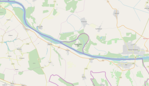
The Šarengradska Ada is an inland island in the Danube , which is disputed between the province of Vojvodina , Northern Serbia and the County of Vukovar-Srijem , Eastern Croatia .
Within the former Yugoslavia , the island, which is named after the place Šarengrad on the Croatian shore , belonged to the Republic of Croatia . With the break-up of Yugoslavia, a parallel Serbian state was founded on Croatian territory (the so-called Republic of Serbian Krajina ), which also included parts of East Slavonia on the border with Serbia . The entire Croatian bank of the Danube was part of this unrecognized republic. When the western and most important areas of the Serbian Republic of Krajina were conquered by Croatian troops in the summer of 1995 , only Eastern Slavonia remained under Serbian control.
In the Erdut Agreement , the Serbian and Croatian sides agreed to return Eastern Slavonia to Croatian administration by peaceful means. Regardless of the fact that before the war Croatia had floodplains to the left of the Danube and numerous river islands which protruded into the Serbian territory, the central reaches of the Danube was defined as the state border between Serbia and Croatia . Accordingly, the Šarengradska Ada has been officially on Serbian territory since 1998. Croatia, on the other hand, demands the return of the 115 km² islands and floodplain landscapes on the left, Serbian bank of the Danube.

