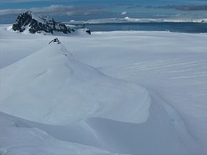
Acheloj-Nunatak
| Acheloj-Nunatak | ||
|---|---|---|
|
Acheloj-Nunatak (in the foreground) |
||
| height | 390 m | |
| location | Livingston Island , South Shetland Islands | |
| Coordinates | 62 ° 38 '23 " S , 60 ° 7' 54" W | |
|
|
||
|
Map of the Tangra Mountains with the Acheloj Nunatak (Aheloy Nunatak) |
||
The Acheloj Nunatak ( Bulgarian Ахелойски нунатак Achelojski nunatak ; English Aheloy Nunatak ) is a 390 m high nunatak on Livingston Island in the archipelago of the South Shetland Islands . It rises 1.6 km east-southeast of the Kuzman Knoll , 2.55 km south of the Maritsa Peak and 1.6 km north-northeast of the Zograf Peak and 275 m north-northeast of the Erma Knoll from the Huron Glacier . In the Tangra Mountains , it forms the north-eastern extension of a mountain ridge to which the Erma Knoll and the Losen-Nunatak belong and which is connected to the Zograf Peak via the Lozen Saddle .
Bulgarian scientists mapped it between 2004 and 2005. The Bulgarian Commission for Antarctic Geographical Names named it in 2005 after a town on the Bulgarian Black Sea coast .
Web links
- Aheloy Nunatak in the Composite Gazetteer of Antarctica (English)


