Aguinaldo (Ifugao)
| Municipality of Aguinaldo | ||
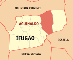
| Location of Aguinaldo in Ifugao Province | ||
|---|---|---|

|
||
| Basic data | ||
| Region : | Cordillera administrative region | |
| Province : | Ifugao | |
| Barangays : | 16 | |
| District: | 1st district of Ifugao | |
| PSGC : | 142708000 | |
| Income class : | 3rd income bracket | |
| Households : | 3341 May 1, 2000 census
|
|
| Population : | 19,408 August 1, 2015 census
|
|
| Population density : | 36.1 inhabitants per km² | |
| Area : | 538.06 km² | |
| Coordinates : | 16 ° 15 ′ N , 121 ° 21 ′ E | |
| Postal code : | 3606 | |
| Mayor : | Dolphin B. Bullan | |
| Geographical location in the Philippines | ||
|
|
||
Aguinaldo is a municipality in the Ifugao Province of the Philippines .
The main industry is agriculture.
geography
Aguinaldo is one of eleven municipalities in Ifugao Province, it is bordered to the west by Mayoyao and Lagawe , to the east by Alfonso Lista , to the north by Natonin in the province of Mountain Province and to the south by the reservoir of the largest dam in the Philippines, the Magat Dam . Aguinaldo is located about 386 km north of Manila , 102 km northeast of the provincial capital Lagawe and 68 km from Santiago City . The eastern and southern parts of the municipality are hilly and are located 200 to 800 m above sea level. The northern and western areas, where several centuries old rice terraces can be found, are mountainous and lie between 600 and 1645 m above sea level. The highest mountain is the Ambalawag , the second highest of the Angnge is 2.3 km from the town center and is the location of the communication relay.
Barangays
Aguinaldo is politically divided into 16 barangays .
|
|
|
Population structure
The majority of the population belongs to the ethnic groups of the Ayangans and the Henangas, a smaller number of the inhabitants belong to the ethnic groups of the Ilokanos , Bontocs , Kalingas and other ethnic groups.
history
Agunialdo was named after the first President of the Philippines, Emilio Aguinaldo . The municipality, like the municipality of Alfonso Lista, used to belong to the municipality of Mayoyao , both of which belong to the Ifugao province . The law on the formation of the municipality of Aguinaldo was signed on September 20, 1980 by the then President Ferdinand Marcos and ratified on December 6, 1980 in a referendum by the residents of Aguinaldo.
economy
Most of the population lives as farmers. Rice and grain cultivation as well as fishing are the most important sources of income. Marketing these agricultural products is difficult due to the small number of possible buyers and poor transport infrastructure. Cattle are resold to Pangasinan by local buyers .
