al-Amiriya
| Al-Amiriya | ||
|---|---|---|
| location | ||
|
|
||
| Coordinates | 33 ° 18 ′ N , 44 ° 17 ′ E | |
| Country |
|
|
| Governorate | Baghdad | |
| District | al-Kark | |
| Basic data | ||
| height | 40 m | |
| prefix | 1 (city), 964 (country) | |
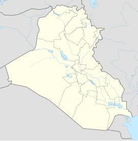
Al-Amiriya ( Arabic العامرية, DMG al-ʿĀmirīya ) is a district of the Iraqi capital Baghdad in the district of al-Karch (arab.الكرخ) on the western city limits.
location
The district is located between two main arterial roads from Baghdad: the road to Baghdad Airport and the road to the city of Abu Ghraib in the west of the country. The population is offered a comparatively good infrastructure and educational facilities.
history
Amiriya was not established until the late 1960s. The influx of many Sunnis from western Iraq in the province of al-Anbar made Amiriya a predominantly Sunni area. A very high percentage of the population comes from the Dulaimi Kubaisi and Bel and Dari clans , all Anbar; but there are also a small number of Shiite Arabs , Kurds and non-Muslims.
Al-Amiriya became internationally known during the Second Gulf War, in particular through the incident on February 13, 1991, when the US Air Force destroyed an air raid shelter with two precision bombs , which it regarded as a military command center and thus a “legitimate military target”, resulting in over 400 civilians perished. The US government regretted the loss of life.
Web links
Individual evidence
- ↑ "Shock and Horror" ( Die Zeit 13/2003)
- ↑ Needless Deaths in the Gulf War: Introduction and Summary of Conclusions ( Human Rights Watch )
- ↑ http://www.nodo50.org/csca/english/al-amiriya/al-amiriya_eng.html ( Al-Amiriya Center for Documentation and International Initiatives , Madrid)

