Almacave
| Almacave | ||||||
|---|---|---|---|---|---|---|
|
||||||
| Basic data | ||||||
| Region : | Norte | |||||
| Sub-region : | Douro | |||||
| District : | Viseu | |||||
| Concelho : | Lamego | |||||
| Coordinates : | 41 ° 6 ′ N , 7 ° 48 ′ W | |||||
| Residents: | 8745 (as of June 30, 2011) | |||||
| Surface: | 10.33 km² (as of January 1, 2010) | |||||
| Population density : | 847 inhabitants per km² | |||||
| Postal code : | 5100-140 | |||||
| politics | ||||||
| Mayor : | António Manuel de Magalhães Rodrigues Lourenço | |||||
| Address of the municipal administration: | Junta de Freguesia de Almacave Rua Dr. Justino P. Oliveira, n.º 4 - 2º 5100-140 Almacave |
|||||
| Website: | www.almacave.freguesias.pt | |||||
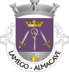
Almacave is a municipality ( freguesia ) in the Portuguese district ( concelho ) of Lamego . It has a population of 8,745 (as of June 30, 2011). It is one of the parishes of Lamegos.
As part of the municipal reorganization, the municipality was merged with Sé on September 29, 2013 to form the União de Freguesias Almacave e Sé or Freguesia de Lamego . The seat of the new municipality will be Almacave after the final implementation.
Attractions
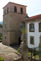
- Santa Maria Church
Sons and daughters
- Alfredo Cardoso de Soveral Martins (1869–1938), colonial administrator and naval officer
- José Maria Pedroto (1928–1985), football player and coach
Web links
Commons : Almacave - collection of images, videos and audio files
Individual evidence
- ↑ a b www.ine.pt - indicator resident population by place of residence and sex; Decennial in the database of the Instituto Nacional de Estatística
- ↑ Overview of code assignments from Freguesias on epp.eurostat.ec.europa.eu
- ^ Page of the municipalities of the website of the district administration (under O Concelho and there under Freguesias ), accessed on December 9, 2013


