
Alteingrat
| Alteingrat | ||
|---|---|---|
 Alteingrat as seen from Davos Frauenkirch . |
||
| height | 2377 m above sea level M. | |
| location | Graubünden , Switzerland | |
| Mountains | Plessur Alps | |
| Coordinates | 776 811 / 178665 | |
|
||

The Alteingrat is (at its most easterly point) 2377 m above sea level. M. high mountain ridge in the Swiss canton of Graubünden . Due to its exposed and distinctive location at the southern end of the Landwasser Valley, it is a memorable landmark in the Davos landscape .
Origin of name
The name Altein comes from Alp Tein, the old name for the alpine area of Davos Wiesen ( Rhaeto-Romanic Tein ).
description
To the north, the Alteingrat slopes down to the Bärental with a steep face known as the Bender. To the west, the Altein Tiefenberg joins the Altein Fürggli with the Alteinsee, which drains over the Alteinbach into the Welschtobelbach. To the south, the Alteingrat slopes gently towards Davos Wiesen. A scenic hiking trail runs along the ridge, which can be reached via Davos Glaris , Davos Wiesen or Arosa .
gallery
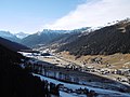
Landwassertal with Alteingrat at the end
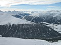
Alteingrat seen from the Jakobshorn

Historical aerial view


Individual evidence
- ↑ Alteingrat in the Geographical Dictionary of Switzerland called on 8 April 2018th
- ↑ Swisstopo Alteingrat accessed on April 8, 2018.