Altin Köprü
| Altin Köprü | ||
|---|---|---|
| location | ||
|
|
||
| Coordinates | 35 ° 45 ′ N , 44 ° 8 ′ E | |
| Country |
|
|
| Governorate | Kirkuk | |
| District | Kirkuk | |
| Basic data | ||
| height | 250 m | |
| Residents | 9,110 (2010) | |
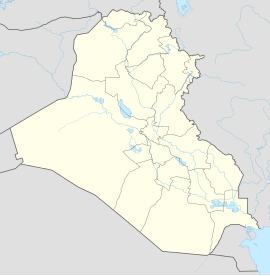
Altin Köprü (التون كوپرو Altūn Kūprū , Arabic : Al-Qantara ; Kurdish : Pirde ) is an Iraqi city in Kirkuk Governorate . Altin Köprü is located on the Kleiner Zab at an altitude of 250 m on the border with the Arbil governorate . The Erbil-Kirkuk railway line runs north of the city. According to calculations, the city has 9110 inhabitants, who are predominantly Turkmen . In addition, still live Kurds and Arabs in the city. Most of the city's residents work in agriculture or in the Kirkuk oil fields.
The name of the city comes from Turkish ( South Azerbaijani dialect) and means Golden Bridge (Turkey-Turkish: Altınköprü). The Kurdish and Arabic names of the city both mean bridge .
Altin Köprü was founded on a rock in the Zab and today extends far beyond the island. In the Middle Ages the place was an insignificant village and became an important trading point after the construction of two bridges in the 16th century by the Ottomans . In 1918 one of the bridges was destroyed and replaced by a steel bridge. After the end of the First World War , the area around Altin Köprü became part of the British Mandate Mesopotamia and then part of the new state of Iraq.
Individual evidence
- ↑ a b Archived copy ( memento of the original dated December 29, 2011 in the Internet Archive ) Info: The archive link was inserted automatically and has not yet been checked. Please check the original and archive link according to the instructions and then remove this notice.
swell
- Stephen H. Longrigg: Altin Köprü . In: The Encyclopaedia of Islam. New Edition , Vol. 1 . Brill, Leiden 2000, ISBN 90-04-11635-4 .
