Am Stern (Kassel)
| At the star | |
|---|---|
| Place in Kassel | |
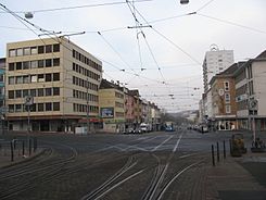
 the intersection Am Stern in the direction of Holländischer Platz |
|
| Basic data | |
| place | kassel |
| District | center |
| Created | after 1950 |
| Confluent streets | Kurt-Schumacher-Strasse, Untere Königstrasse |
| use | |
| User groups | Pedestrian traffic , bicycle traffic , car traffic , public transport |
Am Stern is the name of a square and traffic junction in the city center of the north Hessian city of Kassel .
The square in its current form was created during the reconstruction period in the 1950s. It is characterized by a high volume of traffic through private and public transport , as well as a large number of different restaurants and retail establishments.
An extension of the B 7 , which leads from the north into the city , meets here through Untere Königsstraße on Landesstraße 3237 on the so-called Kassel inner city ring. The Am Stern public transport stop is served by all lines of the Kassel tram and several central bus lines.
The square, popularly known as just a star, is the beginning of a sequence of squares through the center of Kassel. In this series, follow along the royal road of the king place , the Friedrichsplatz and the Brothers Grimm space . Like the previously mentioned places, the star is characterized by its shape. This is formed by a rectangle , which is given a special accent by a high-rise building on the western edge of the square. From the star there are special visual connections to the Altmarkt , the old city center on the Fulda, and towards Holländischer Platz , the old city entrance and today's location of the University of Kassel .
Coordinates: 51 ° 19 ′ 5.2 " N , 9 ° 30 ′ 1.1" E