Ambitle (volcano)
| Ambitle | ||
|---|---|---|
|
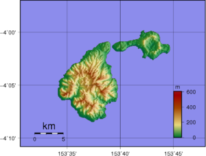
Topographic map of the Feni Islands . Ambitle is the western island |
||
| height | 450 m | |
| location | Bismarck Archipelago , New Ireland , Papua New Guinea | |
| Coordinates | 4 ° 5 ′ 0 ″ S , 153 ° 39 ′ 0 ″ E | |
|
|
||
| Type | Stratovolcano | |
| Last eruption | 350 BC Chr. ± 100 years | |
The Ambitle is a volcano on Ambitle , one of the Feni Islands belonging to Papua New Guinea , New Ireland Province . The summit area of the stratovolcano consists of a caldera with a diameter of three kilometers and several lava domes. To the east is a maar that was formed in an eruption around 2300 years ago. On the west side of the caldera floor there are several thermally active areas with hot springs, boiling mud ponds and fumaroles .
source
- Ambitle in the Global Volcanism Program of the Smithsonian Institution (English)

