
New Ireland Province
| New Ireland | |
|---|---|

|
|
| geography | |
| Country: | Papua New Guinea |
| Waters: | Pacific Ocean |
| Islands: | 149 |
| Geographical location: | 3 ° 23 ′ S , 151 ° 59 ′ E |
| Basic data | |
| Surface: | 9600 km² |
| Residents: | 194.067 |
| Population density: | 20 inhabitants / km² |
| Capital: | Kavieng |
| Situation map | |
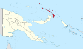  |
|
New Ireland Province is one of the 21 provinces of Papua New Guinea and is located in the Bismarck Archipelago . It comprises 149 islands, the largest of which is New Ireland (formerly Neumecklenburg), which gave the province its name.
The New Ireland Province (NIP) covers 9600 km² and counted around 194,000 inhabitants in 2011 (about 20 inhabitants per km²). Its capital is Kavieng on the northern cape of the main island of New Ireland with 12,000 inhabitants. In addition to New Ireland with 8650 km² there are two somewhat larger islands: Lavongai (formerly Neuhannover) with 1191 km² and the main town Umbukul, and the sparsely populated Mussau Island in the north of the province, which belongs to the St. Matthias Islands . The New Ireland Province also includes the small archipelagos of the Tabar Islands and the Lihir Islands on the northeast Pacific side, and the Tingyon Group and Dyaul Island on the southwest side in the Bismarck Sea . On the volcanic island of Niolam (Lihir) there is a gold mine that has one of the largest gold deposits in the world.
Districts and LLGs

The Province of New Ireland is divided into two districts. Each district consists of one or more "areas at the local administrative level", Local Level Government (LLG) Areas , which are divided into Rural (rural) or Urban (urban) LLGs.
| District | Administrative center | Designation of the LLG areas |
|---|---|---|
| Kavieng District | Kavieng | Kavieng Urban |
| Lavongai Rural | ||
| Murat Rural | ||
| Tikana Rural | ||
| Namatanai District | Namatanai | Konoagil Rural |
| Namatanai Rural | ||
| Nimamar Rural | ||
| Sentral Niu Ailan Rural | ||
| Tanir Rural |
See also
- New Ireland (main island New Ireland, formerly Neumecklenburg)
- New Britain (western neighboring island New Britain, formerly New Pomerania)
- List of provinces of Papua New Guinea
- List of German names for Papua New Guinea places
Web links
Individual evidence
- ↑ 2000 Census: Population by Province, PNG, 2000 Census. In: A Tourism Guide to Papua New Guinea. Papua New Guinea Business Directory. Retrieved August 1, 2013.
- ↑ Official website : National Statistical Office of Papua New Guinea. Port Moresby. Retrieved on August 1, 2013. Info: Without any information value, as no freely accessible data is offered!
Bougainville | Central | Eastern Highlands | East New Britain | East Sepik | Enga | Gulf | Hela | Jiwaka | Madang | Manus | Milne Bay | Morobe | New Ireland | Oro | Sandaun | Simbu (Chimbu) | Southern Highlands | Western | Western Highlands | West New Britain | National Capital District (Port Moresby)