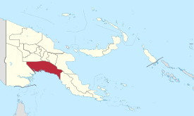
Gulf Province (Papua New Guinea)
| Gulf (Goeland) |
|
|---|---|

|
|
| geography | |
| Country: | Papua New Guinea |
| Waters: | Pacific Ocean |
| Islands: | ( located in New Guinea ) |
| Geographical location: | 7 ° 20 ′ S , 145 ° 0 ′ E |
| Basic data | |
| Surface: | 34,500 km² |
| Residents: | 158.197 |
| Population density: | 5 inhabitants / km² |
| Capital: | Kerema |
| Situation map | |
Gulf is one of the 21 provinces of Papua New Guinea . Gulf is around 34,500 km² and in 2011 had around 158,197 inhabitants. The capital is Kerema with 5116 inhabitants in 2000 - about three times as many as in 1980.
The Gulf Province is located on the rainy south coast of the country on the eponymous Gulf of Papua . The area is unsuitable for road construction because of swamps and alluvial land, so there are only 200 km of roads and traffic takes place on the water or by plane. The airfields are often flooded by floods and rainfall.
About 15 large rivers and several rivers run through the province. The living conditions are so unfavorable that the country is sparsely populated and 30% of those born here emigrate to other provinces. There are no major cities. Until 1951 the area consisted of two provinces, Gulf and Delta .
The Motu who live around Port Moresby used to exchange palm meal on their Hiri trade trips lasting several months , especially in the area of the Gulf province of Sago . Sago flour is not rich in protein , however . As elsewhere on the island, headhunting used to be common in the Gulf Province .
Four main tribes inhabit the province: the Delta people on the coast are semi-nomads and are considered lazy. The sedentary Elema inland have a reputation for being more industrious artists. The kamea on the border with Morobe province are small, stocky and are considered to be very belligerent. The Namau on the coast are known for cult objects recreated from strange monsters .
Districts and LLGs
The Gulf Province is divided into two districts. Each district consists of one or more "areas at the local administrative level", Local Level Government (LLG) Areas , which are divided into Rural (rural) or Urban (urban) LLGs.
| District | Administrative center | Designation of the LLG areas |
|---|---|---|
| Kerema district | Kerema | Central Kerema Rural |
| East Kerema Rural | ||
| Kaintiba Rural | ||
| Kerema Urban | ||
| Kotidanga Rural | ||
| Lakekamu-Tauri Rural | ||
| Kikori District | Kikori | Baimuru Rural |
| East Kikori Rural | ||
| Ihu Rural | ||
| West Kikori Rural |

