Western Highlands Province
| Western Highlands | |
|---|---|

|
|
| geography | |
| Country: | Papua New Guinea |
| Waters: | |
| Islands: | ( located in New Guinea ) |
| Geographical location: | 5 ° 50 ′ S , 144 ° 15 ′ E |
| Basic data | |
| Surface: | 8288 km² |
| Residents: | 362,850 |
| Population density: | 44 inhabitants / km² |
| Capital: | Mount Hagen |
| Situation map | |
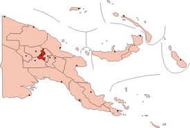
Western Highlands is one of the 21 provinces of Papua New Guinea . With 8,288 km² and just over 362,850 inhabitants in 2011, the province is one of the smallest and most densely populated in the country. The capital is Mount Hagen with 46,256 inhabitants (census in 2013).
Western Highlands has a diverse landscape. Between the peppered with four-thousand-peaks mountain ranges Kuborgebirge and Bismarck Range in the south and north there are forests, mountain savannas, grasslands and horticulture. The Highland Highway has good transport links for tourism, and the cultivation of tea and coffee is important.
Western Highlands belonged to the German colony of German New Guinea . The capital Mount Hagen was named after the German administrative officer Curt von Hagen . In 1951 the highland area was divided into different provinces, and in 1968 the Enga province was split off from Western Highlands. The Western Highlands area has traditionally been a meeting place for highland trade.
The neighboring provinces are Jiwaka in the east, Madang in the north, Enga in the west and Southern Highlands in the south.
population
The highland dwellers are mostly small in stature and have medium brown skin. As is usually the case in Papua New Guinea, there are many very small tribes and language groups such as Jiwaka , Jate , Manga and Kuma , but also some large ones such as the Metlpa . Ma-Enga and Roni grow tea. Many tribes have an intense ancestor cult .
Districts and LLGs
The Western Highlands Province is divided into seven districts. Each district consists of one or more "areas at the local administrative level", Local Level Government (LLG) Areas , which are divided into Rural (rural) or Urban (urban) LLGs.
| District | Administrative center | Designation of the LLG areas |
|---|---|---|
| Anglimp-South Waghi District | Minj | Anglimp Rural |
| South Waghi Rural | ||
| The district | Dei | Muglamp Rural |
| Kotna Rural | ||
| Mount Hagen District | Mount Hagen | Mount Hagen Rural |
| Mount Hagen Urban | ||
| Mul-Baiyer District | Baiyer | Baiyer Rural |
| Lumusa Rural | ||
| Mul Rural | ||
| Jimi District | Tabibuga | Jimi Rural |
| Kol Rural | ||
| North Waghi District | Banz | North Waghi Rural |
| Nondugl Rural | ||
| Tambul-Nebilyer District | Nebilyer | Mount Giluwe Rural |
| Nebilyer Rural |
literature
- Heiner Wesemann: Papua New Guinea. Niugini. Stone Age Cultures on the Way to the 20th Century. DuMont, Cologne 1985, ISBN 3-7701-1322-5 ( DuMont culture travel guide in the series DuMont documents ).
