
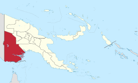
Western Province (Papua New Guinea)
| Western Province | |
|---|---|

|
|
| geography | |
| Country: | Papua New Guinea |
| Waters: | Pacific Ocean |
| Islands: | ( located in New Guinea ) |
| Geographical location: | 7 ° 20 ′ S , 142 ° 0 ′ E |
| Basic data | |
| Surface: | 99,600 km² |
| Residents: | 153,000 |
| Population density: | 2 inhabitants / km² |
| Capital: | Daru |
| Situation map | |
  |
|
Western or Fly River is the name of one of the 21 provinces of Papua New Guinea . The province on the western border of the country with Indonesia is about 99,600 km² and has around 153,000 inhabitants. This makes the Western Province the largest and most sparsely populated in the country. The capital is Daru with 12,879 inhabitants in 2000. It is located on the island of the same name at the mouth of the Fly River .
geography

The provinces of Gulf and Southern Highlands form the border in the east and Sandaun in the north of the western province. The Indonesian province of Papua is in the west. The situation on the border with neighboring Indonesia is a bit tense at times. To the south, the Torres Strait forms a natural boundary.
The province is dominated by the Fly River , a stream that is 80 km wide at its mouth. Because of the fly, the border with Indonesia was also changed, which otherwise runs along the 141st degree of longitude, but adapts to the course of the current here. The vast grasslands are often inundated by floods . Most of the province is lowland, swamp and tropical rainforest .
In the north there is a of limestone caves laced plateau , in the northwest of the mountain ranges of the Hindenburg - and Müller-range . The province has remained economically insignificant, although large copper and gold deposits have recently been discovered. The road is difficult, which is why the traffic mainly runs on waterways and by air.
In the Western Province is the country's largest lake , Lake Murray , home to many crocodiles . In addition to pearls , crocodile skins were also one of the most important trade items in the capital Daru, which is located on an island off the coast. Today fish is mainly processed in the small port town .
population
The Tugeri live in the high plateau , who used to be headhunters and who are said to have had the custom of killing an adult for every newborn baby in their tribe. The seafaring tribes of the Kiwai and Gogodala live on the coast .
Districts and LLGs

Western Province is divided into three districts. Each district consists of one or more "areas at the local administrative level", Local Level Government (LLG) Areas , which are divided into Rural (rural) or Urban (urban) LLGs.
| District | Administrative center | Designation of the LLG areas |
|---|---|---|
| Middle Fly District | Balimo | Balimo Urban |
| Bamu Rural | ||
| Gogodala Rural | ||
| Lake Murray Rural | ||
| Nomad Rural | ||
| North Fly District | Kiunga | Kiunga Rural |
| Kiunga Urban | ||
| Ningerum Rural | ||
| Olsobip Rural | ||
| Star Mountains Rural | ||
| South Fly District | Daru | Daru Urban |
| Kiwai Rural | ||
| Morehead Rural | ||
| Oriomo-Bituri Rural |
See also
literature
- Heiner Wesemann: Papua New Guinea. Niugini. Stone Age Cultures on the Way to the 20th Century. DuMont, Cologne 1985, ISBN 3-7701-1322-5 ( DuMont culture travel guide in the series DuMont documents ).
Web links
Individual evidence
Bougainville | Central | Eastern Highlands | East New Britain | East Sepik | Enga | Gulf | Hela | Jiwaka | Madang | Manus | Milne Bay | Morobe | New Ireland | Oro | Sandaun | Simbu (Chimbu) | Southern Highlands | Western | Western Highlands | West New Britain | National Capital District (Port Moresby)