Ammassalik Island
| Ammassalik Island | ||
|---|---|---|
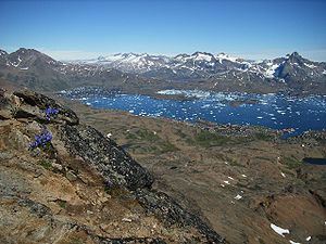
| View from Sømandsfjetzt towards Tasiilaq and Kong Oscar Havn | ||
| Waters | Irmingersee | |
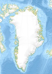
| Geographical location | 65 ° 43 ′ N , 37 ° 35 ′ W | |
|
|
||
| length | 37.5 km | |
| width | 31 km | |
| surface | 772 km² | |
| Highest elevation | 1352 m | |
| Residents | 2093 2.7 inhabitants / km² |
|
| main place | Tasiilaq | |
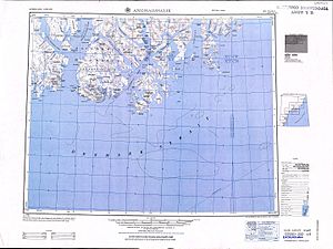
| Topographic map sheet from 1952 with Angmagssalik Ö and the surrounding area | ||
The Ammassalik Island ( Danish Ammassalik Ø or Angmagssalik Ø ) is an island on the southeast coast of Greenland in the Irminger Sea . Administratively it belongs to the Kommuneqarfik Sermersooq , and in it to the district (former municipality) Tasiilaq. It is one of the ten largest minor islands in Greenland and is the largest island in the Tasiilaq district.
geography
The Ammassalik Island is the Greenlandic mainland by the fjord Sermilik the west and the Straits separated Tiniteqilaq and Ikerasagssuaq (Ikasagtivaq) in the north and northeast. A group of other islands lies behind the Ammassaliip Kangertiva in the southeast. The island is 37.5 km long and 31 km wide. Its area is 772 km. The city of Tasiilaq , the only inhabited settlement on the island, has 2093 inhabitants (as of 2015). In the drainage basin of the Mittivakkat (Mitdluagkat) glacier in the west of the island is the glaciological Sermilik research station , where up to ten scientists can live and work in summer.
The interior of the island is characterized by mountainous terrain of an alpine character, which reaches an altitude of 1352 m in an unnamed peak in the north. In the southern part, Vegas Fjeld (1084 m) is the dominant peak. The largest glaciers are the Mittivakkat glacier in the east and the Tinit glacier in the north. Both lost almost 20% of their area between 1986 and 2011.
The south-east coast of Ammassalik Island in particular is strongly indented by fjords. In the hinterland there are several lakes, the largest of which is Qordlortoq Sø.
history
Millennia before Europeans "discovered" the Ammassalik Island, it was already inhabited by humans. It is not known whether this settlement was continuous. Archaeological finds show that as early as 1900 BC Paleo-Eskimos of the Saqqaq culture lived on the island. Traces of the later Dorset culture have also been found here. From the 14th century, groups of Neo-Eskimos migrated to the Thule culture in several waves.
It is not known whether the Norwegian Grænlendingar , who lived in two settlements on the southwest coast of Greenland in the Middle Ages , ever set foot on Ammassalik Island. Probably the first European to set foot on the island was the Danish naval officer Gustav Frederik Holm , who led the so-called women's boat expedition from 1883 to 1885 . He circumnavigated Cape Farvel with his umiaks , followed the coast to the Arctic Circle and made the first contact with the Inuit on Ammassalik Island. Ten years later the Danish mission was founded in Ammassalik, now Tasiilaq.
See also
Individual evidence
- ↑ Sailing Directions. Pub. 181: Greenland and Iceland (Enroute) (PDF; 5.5 MB), Ninth Edition, National Geospatial-Intelligence Agency, Springfield, Virginia, 2011, p. 104 (English)
- ↑ Per Ivar Haug: Gazetteer of Greenland ( Memento from June 15, 2011 in the Internet Archive ) (= Til Oppslysning 15). Universitetsbiblioteket i Trondheim, Trondheim 2005, ISBN 82-7113-114-1 (English), accessed on September 24, 2015.
- ↑ History and facilities on the homepage of the Sermilik-Station (English), accessed on September 24, 2015.
- ↑ SH Mernild, JK Malmros, JC Yde, NT Knudsen: Multi-decadal marine- and land-terminating glacier recession in the Ammassalik region, southeast Greenland (PDF; 8.5 MB). In: The Cryosphere 6, 2012, pp. 625-639, doi: 10.5194 / tc-6-625-2012 .
- ^ Joelle Robert-Lamblin: Ammassalik, East Greenland - end or persistance of an isolate? (= Meddelelser om Grønland. Man & Society , 10/1986), pp. 9-11. limited preview in Google Book search


