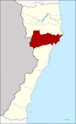
Amphoe Kui Buri
|
Kui Buri กุยบุรี |
|
|---|---|
| Province: | Prachuap Khiri Khan |
| Surface: | 935.4 km² |
| Residents: | 44,018 (2013) |
| Population density : | 44.09 U / km² |
| ZIP : | 77150 |
| Geocode : | 7702 |
| map | |

|
|
Amphoe Kui Buri ( Thai : อำ เภ อ กุยบุรี ) is a district ( Amphoe - administrative district) in the northern part of the province of Prachuap Khiri Khan . The province of Prachuap Khiri Khan is the southernmost province of the central region of Thailand .
geography
Neighboring Amphoe and Areas: in the north is Amphoe Sam Roi Yot , in the south Amphoe Mueang Prachuap Khiri Khan . To the west is the Tanintharyi Division of Myanmar and to the east is the coast to the Gulf of Thailand .
history
Müang Kui was an ancient city ( Müang ) in the Kingdom of Ayutthaya. During the reign of King Boromakot , Kui was a "4th class city", its governor had the title Phra Kui Buri . In the Rattanakosin period, King Phutthaloetla Naphalai (Rama II) set up a Müang Bang Nang Rome, the administrative building of which was in Kui Buri. King Mongkut (Rama IV.) Renamed “Müang Bang Nang Rom” to “Prachuap Khiri Khan”, but left the administration in the same place. When King Chulalongkorn (Rama V.) established the “ Monthon Phetchaburi”, Kui Buri was included. In 1898 the administration building was relocated to Ko Lak and Kui Buri became a tambon of Müang Prachuap Khiri Khan. On July 19, 1960, Kui Buri got the status of a "branch circle" ( King Amphoe ) and on July 16, 1963, the full Amphoe status.
administration
Provincial Administration
The district of Kui Buri is divided into six tambon ("subdistricts" or "communities"), which are further divided into 47 muban ("villages").
| No. | Surname | Thai | Muban | Pop. |
|---|---|---|---|---|
| 1. | Kui Buri | กุยบุรี | 8th | 10,384 |
| 2. | Kui Nuea | กุย เหนือ | 11 | 6,590 |
| 3. | Khao Daeng | เขา แดง | 3 | 2.157 |
| 4th | Don Yai Nu | ดอน ยาย หนู | 4th | 3,170 |
| 6th | Sam Krathai | สาม กระทาย | 10 | 10,917 |
| 7th | Has Kham | หาด ขาม | 11 | 10,800 |
Local administration
There are two municipalities with "small town" status ( Thesaban Tambon ) in the district:
- Kui Buri (Thai: เทศบาล ตำบล กุยบุรี ) consisting of the parts of the Tambon Kui Buri, Kui Nuea.
- Rai Mai (Thai: เทศบาล ตำบล ไร่ ใหม่ ) consisting of parts of the Tambon Sam Krathai and parts of the Tambon Rai Mai of the neighboring Amphoe Sam Roi Yot .
In addition, there are six " tambon administration organizations " ( องค์การ บริหาร ส่วน ตำบล - Tambon Administrative Organizations, TAO)
- Kui Buri (Thai: องค์การ บริหาร ส่วน ตำบล กุยบุรี ) consisting of parts of the Tambon Kui Buri.
- Kui Nuea (Thai: องค์การ บริหาร ส่วน ตำบล กุย เหนือ ) consisting of parts of the Tambon Kui Nuea.
- Khao Daeng (Thai: องค์การ บริหาร ส่วน ตำบล เขา แดง ) consisting of the complete Tambon Khao Daeng.
- Don Yai Nu (Thai: องค์การ บริหาร ส่วน ตำบล ดอน ยาย หนู ) consisting of the complete tambon Don Yai Nu.
- Sam Krathai (Thai: องค์การ บริหารส่วน ตำบล สาม กระทาย ) consisting of parts of the Tambon Sam Krathai.
- Hat Kham (Thai: องค์การ บริหาร ส่วน ตำบล หาด ขาม ) consisting of the complete Tambon Hat Kham.
Individual evidence
- ↑ พระราชกฤษฎีกา ตั้ง อำเภอ บ่อพลอย อำเภอ ไทรโยค อำเภอ หนอง ปรือ อำเภอ หนองสองห้อง อำเภอ ประทาย อำเภอ ห้วยแถลง อำเภอ ละหานทราย อำเภอ กุยบุรี อำเภอ ตาพระยา อำเภอ หนองไผ่ อำเภอ นาเชือก นาเชือก อำเภอ วัดเพลง อำเภอ พนัสนิคม อำเภอ อำเภอ ภูกระดึง อำเภอ ปรางค์กู่ อำเภอ ท่าช้าง อำเภอ บ้านด่านลานหอย อำเภอ บ้านดุง อำเภอ สว่างอารมณ์ และ อำเภอ กุดชุม พ.ศ. ๒๕๐๖ Royal Gazette, Vol. 80, Ed. 72 ก , July 16, 1963, pp. 362–366 (in Thai)
- ↑ 2013 population statistics ( Thai ) Department of Provincial Administration. Retrieved September 11, 2014.
Web links
Coordinates: 12 ° 5 ' N , 99 ° 51' E

