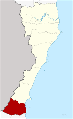
Bang Saphan Noi district
|
Bang Saphan Noi บางสะพาน น้อย |
|
|---|---|
| Province: | Prachuap Khiri Khan |
| Surface: | 720.0 km² |
| Residents: | 37,366 (2013) |
| Population density : | 49.37 U / km² |
| ZIP : | 77170 |
| Geocode : | 7705 |
| map | |

|
|
Amphoe Bang Saphan Noi ( Thai : อำเภอ บางสะพาน น้อย ) is the southernmost district ( Amphoe - administrative district) of the province of Prachuap Khiri Khan . The province of Prachuap Khiri Khan is the southernmost province of the central region of Thailand .
geography
Adjacent counties and areas: Bang Saphan District Prachuap Khiri Khan is located north, Tha Sae District and Pathio District of Chumphon province south of the district. To the west is the Tanintharyi Division of Myanmar and to the east is the Gulf of Thailand .
history
The area of today's Bang Saphan Noi County originally belonged to the Bang Saphan district. On June 10, 1974, it was initially set up as a "branch circle" ( King Amphoe ) . On July 13, 1981, it was officially given full amphoe status.
administration
Provincial Administration
Bang Saphan Noi County is divided into five tambon ("subdistricts" or "parishes"), which are further subdivided into 41 muban ("villages").
| No. | Surname | Thai | Muban | Pop. |
|---|---|---|---|---|
| 1. | Pak Phraek | ปาก แพรก | 6th | 3,395 |
| 2. | Bang Saphan | บางสะพาน | 10 | 7,984 |
| 3. | Sai Thong | ทราย ทอง | 11 | 7.153 |
| 4th | Chang Raek | ช้าง แรก | 8th | 10,357 |
| 5. | Chaiyarat | ไชย ราช | 6th | 8,477 |
Local administration
There is one municipality with "small town" status ( Thesaban Tambon ) in the district:
- Bang Saphan Noi (Thai: เทศบาล ตำบล บางสะพาน น้อย ) consisting of parts of the Tambon Bang Saphan.
There are also five " tambon administration organizations " ( องค์การ บริหาร ส่วน ตำบล - Tambon Administrative Organizations, TAO)
- Pak Phraek (Thai: องค์การ บริหาร ส่วน ตำบล ปาก แพรก ) consisting of the complete Tambon Pak Phraek.
- Bang Saphan (Thai: องค์การ บริหาร ส่วน ตำบล บางสะพาน ) consisting of parts of the Tambon Bang Saphan.
- Sai Thong (Thai: องค์การ บริหาร ส่วน ตำบล ทราย ทอง ) consisting of the complete tambon Sai Thong.
- Chang Raek (Thai: องค์การ บริหารส่วน ตำบล ช้าง แรก ) consisting of the complete Tambon Chang Raek.
- Chaiyarat (Thai: องค์การ บริหาร ส่วน ตำบล ไชย ราช ) consisting of the complete Tambon Chaiyarat.
Individual evidence
- ↑ ประกาศ กระทรวง มหาดไทย เรื่อง แบ่ง ท้องที่ อำเภอ บางสะพาน จังหวัด ประจวบคีรีขันธ์ ตั้ง เป็น กิ่ง อำเภอ บางสะพาน น้อย Royal Gazette, Vol. 91, Issue 96 ง of June 4, 1974, p. 1526 (in Thai)
- ↑ พระราชกฤษฎีกา ตั้ง อำเภอ หนองใหญ่ อำเภอ บ่อไร่ อำเภอ พรหมคีรี อำเภอ นาบอน อำเภอ บางสะพาน น้อย อำเภอ นาดี อำเภอ กงหรา อำเภอ วังทรายพูน อำเภอ ธารโต อำเภอ คำตากล้า อำเภอ อำเภอ ศรีนคร อำเภอ ด่านช้าง อำเภอ พรเจริญ อำเภอ วังสามหมอ และ อำเภอ ลานสัก พ.ศ. ๒๕๒๔ Royal Gazette, Vol. 98, Ed. 115 ก special ( ฉบับ พิเศษ ) of July 13, 1981, pp. 7-10 (in Thai)
- ↑ 2013 population statistics ( Thai ) Department of Provincial Administration. Retrieved September 11, 2014.
Web links
Coordinates: 11 ° 5 ' N , 99 ° 27' E
