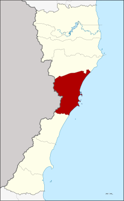
Amphoe Mueang Prachuap Khiri Khan
|
Mueang Prachuap Khiri Khan เมือง ประจวบคีรีขันธ์ |
|
|---|---|
| Province: | Prachuap Khiri Khan |
| Surface: | 830.0 km² |
| Residents: | 88,750 (2013) |
| Population density : | 109.48 U / km² |
| ZIP : | 77000, 77210 |
| Geocode : | 7701 |
| map | |

|
|
Amphoe Mueang Prachuap Khiri Khan (in Thai : อำเภอ เมือง ประจวบคีรีขันธ์ ) is a district ( amphoe - administrative district) in the Prachuap Khiri Khan Province . The province of Prachuap Khiri Khan is located in the southwest of the central region of Thailand .
location
Amphoe Mueang Prachuap Khiri Khan is located on the Gulf of Thailand about 280 km southwest of the capital Bangkok .
Neighboring districts are Amphoe Kui Buri in the north and Amphoe Thap Sakae in the south. In the west lies the border with the Tanintharyi Division of Myanmar , in the east the Gulf of Thailand .
In Tambon Huai Sai, the narrowest part of the landmass of Thailand is on the Malay Peninsula . It is only 11 kilometers from the Gulf coast to the border with Myanmar .
history
In the early Rattanakosin period, King Phra Phutthaloetla (Rama II) founded the city ( Mueang ) Bang Nang Rom at the mouth of the Nang Rom Canal. King Mongkut (Rama IV.) Changed the name from Mueang Bang Nang Rom to Mueang Prachuap Khiri Khan. The name should rhyme with Mueang Patchanta Khiri Khet (now Koh Kong province in Cambodia) on the other side of the Gulf of Thailand. In 1894, King Chulalongkorn (Rama V) placed Mueang Prachuap under the administration of Mueang Phetchaburi. In 1898 he moved the administrative center from Mueang Kui to Ko-Lak Bay (also: Prachuap Bay). In 1906, Mueang Pranburi, Kamnoed Nopphakhun and Prachuap were merged to form the newly established Mueang Pranburi. The new city became the capital of a new province under the administration of Monthon Ratchaburi. In order to avoid confusion of the city names, King Vajiravudh (Rama VI.) Changed the name of the district on Prachuap Bay back to Prachuap Khiri Khan on August 16, 1915.
administration
Provincial Administration
The district of Mueang Prachuap Khiri Khan is divided into six tambon ("subdistricts" or "parishes"), which are further subdivided into 63 muban ("villages").
| No. | Surname | Thai | Muban | Pop. |
|---|---|---|---|---|
| 1. | Prachuap Khiri Khan | ประจวบคีรีขันธ์ | - | 17,994 |
| 2. | Ko Lak | เกาะ หลัก | 11 | 14,493 |
| 3. | Khlong Wan | คลอง วาฬ | 9 | 14,359 |
| 4th | Huai Sai | ห้วย ทราย | 13 | 9,808 |
| 5. | Ao Noi | อ่าว น้อย | 16 | 24,633 |
| 6th | Bo Nok | บ่อ นอก | 14th | 7,463 |
Local administration
There is one commune with "city" status ( Thesaban Mueang ) in the district:
- Prachuap Khiri Khan (Thai: เทศบาล เมือง ประจวบคีรีขันธ์ ) consisting of the complete tambon Prachuap Khiri Khan and the parts of the tambon Ko Lak, Ao Noi.
There are two municipalities with "small town" status ( Thesaban Tambon ) in the district:
- Km 5 (Thai: เทศบาล ตำบล กม. 5 ) consisting of parts of the Tambon Ao Noi.
- Khlong Wan (Thai: เทศบาล ตำบล คลอง วาฬ ) consisting of parts of the Tambon Khlong Wan.
There are also five " tambon administration organizations " ( องค์การ บริหาร ส่วน ตำบล - Tambon Administrative Organizations, TAO)
- Ko Lak (Thai: องค์การ บริหาร ส่วน ตำบล เกาะ หลัก ) consisting of parts of the Tambon Ko Lak.
- Khlong Wan (Thai: องค์การ บริหาร ส่วน ตำบล คลอง วาฬ ) consisting of parts of the Tambon Khlong Wan.
- Huai Sai (Thai: องค์การ บริหาร ส่วน ตำบล ห้วย ทราย ) consisting of the complete tambon Huai Sai.
- Ao Noi (Thai: องค์การ บริหาร ส่วน ตำบล อ่าว น้อย ) consisting of parts of the Tambon Ao Noi.
- Bo Nok (Thai: องค์การ บริหาร ส่วน ตำบล บ่อ นอก ) consisting of the complete tambon Bo Nok.
Individual evidence
- ↑ ประกาศ เปลี่ยน นาม เมือง ปราณบุรี เป็น เมือง ประจวบคีรีขันธ์ . In: Royal Gazette . 32, No. 0 ก , August 22 1915, p. 176.
- ↑ 2013 population statistics ( Thai ) Department of Provincial Administration. Retrieved September 11, 2014.
Web links
Coordinates: 11 ° 48 ' N , 99 ° 48' E
