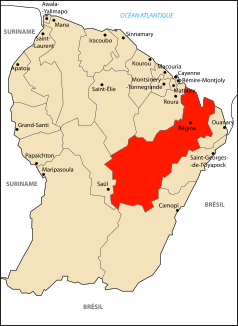
Approuague
| Approuague | ||
|
Catchment area of the river |
||
| Data | ||
| Water code | FR : 80-0200 | |
| location | France , French Guiana region | |
| River system | Approuague | |
| source | in the municipality of Régina 3 ° 12 ′ 41 ″ N , 53 ° 5 ′ 43 ″ W |
|
| Source height | approx. 425 m | |
| muzzle | in the municipality of Régina in the Atlantic Ocean Coordinates: 4 ° 41 ′ 1 ″ N , 51 ° 57 ′ 41 ″ W 4 ° 41 ′ 1 ″ N , 51 ° 57 ′ 41 ″ W |
|
| Mouth height | 0 m | |
| Height difference | approx. 425 m | |
| Bottom slope | approx. 1.3 ‰ | |
| length | 335 km | |
|
The river at Régina |
||
The Approuague is a river in France that runs in the overseas department of French Guiana in the French Guiana region of the same name . It rises in the Emerillon Massif , in the municipality of Régina , drains generally in a north-easterly direction and flows into the Atlantic Ocean after 335 kilometers at Pointe Béhague , still in the municipality of Régina . The river is already exposed to the tides above the town of Régina and thus forms an estuary about 50 kilometers long . In this area it also crosses the Guyana Regional Nature Park (Cayenne sector).
Places on the river
Tributaries
|
Left tributaries: |
Right tributaries:
|
Web links
Commons : Approuague - collection of images, videos, and audio files
Individual evidence
- ↑ a b https://www.geoportail.gouv.fr/
- ↑ a b The information on the length of the river is based on the information on the Approuague from SANDRE (French), accessed on January 2, 2013, rounded to full kilometers.

