
Arapaho National Forest
|
Arapaho National Forest
IUCN Category VI - Protected Area with Sustainable use of Natural Resources |
||
.jpg) View over the area |
||
| location | Colorado , USA | |
| surface | 2929 km² | |
| Geographical location | 39 ° 35 ′ N , 105 ° 39 ′ W | |
|
||
| Setup date | July 1, 1908 | |
| administration | US Forest Service | |
_relief_location_map.png)
The Arapaho National Forest is located in the Rocky Mountains of northern Colorado and covers an area of approximately 2929 km². Together with the Roosevelt National Forest and the Pawnee National Grassland it forms a system known as ARP with a total area of 7420 km². Like all national forests, it is federally owned and is used intensively for forestry purposes.
There are various leisure and recreational activities within the forest. There are many hiking and camping opportunities. Fishing and hunting are also allowed and the mountains are used for winter sports.
Flora and fauna
The forests of the area are dominated in the lower elevations by yellow pines , which are slowly displaced in the higher elevations by Rocky Mountain junipers and coastal pines . In addition, a large number of other tree species, plants and flowers are native.
The diverse lake and river landscape offers optimal living conditions for water birds (including Wilson treaders , mallards , or night herons ) and other bird species. Over 200 different species have been registered in the forest. Including prairie falcons and golden eagles .
Mammals are also diverse. So let Ursons , red deer , silver badgers , or moose watching. The mountain goat was settled by humans in the high altitude regions .
Protected areas within the forest
The Arapaho National Forest includes 6 total reserves that are designated as Wilderness Area :
- Byers Peak Wilderness
- Indian Peaks Wilderness (also located in Roosevelt and Rocky Mountain National Park )
- James Peak Wilderness (located mainly in the Roosevelt National Forest)
- Mount Evans Wilderness (part of the Pike National Forest )
- Never Summer Wilderness (part of the Routt National Forest )
- Vasquez Peak Wilderness
In addition, the Arapaho National Wildlife Refuge is a National Wildlife Refuge adjacent to the area.
history
The National Forest was established on July 1, 1908, on the direction of President Theodore Roosevelt . It was named after the Arapaho Indian people , whose settlement area was originally in the area.
In September 2013, large parts of the forest were affected by flooding. Over 600 km of roads and 250 km of hiking trails had to be repaired.
photos
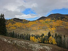
The reserve in October

The Loveland ski area

Sunset on Mount Evans
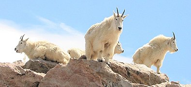
Mountain goats in the park area
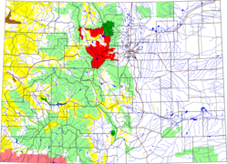
Location of the Arapaho National Forest in Colorado (red)


.jpg)


Web links
See also
Individual evidence
- ↑ "Land Areas of the National Forest (English; PDF 2.82 MB), at www.fs.fed.us in January 2012, accessed on June 16, 2017
- ↑ "Information on the park and its history" , accessed on June 16, 2017
- ^ "Information on tourist activities" , accessed on June 16, 2017
- ↑ Colorado Front Range & Arapahoe-Roosevelt National Forest ( page no longer available , search in web archives ) Info: The link was automatically marked as defective. Please check the link according to the instructions and then remove this notice. (English; PDF , 84 KB), accessed on June 16, 2016
- ^ "Flood Recovery Information" , accessed June 16, 2017