Arizona State Route 347

|
|
|---|---|
| map | |

|
|
| Basic data | |
| Overall length: | 28.5 mi / 45.9 km |
| Starting point: |
|
| End point: |
|
| Counties: |
Pinal County Maricopa County |
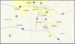
The Arizona State Route 347 (short- AZ 347 ) is a state highway in the US state of Arizona , the South-North direction is in.
The State Route begins on Arizona State Route 84 west of Stanfield and ends 46 kilometers northwest of Sun Lakes on Interstate 10 .
After the junction from AZ 84, State Route 347 runs north to the city of Maricopa . Within the village, Arizona State Route 238 branches off to the west and AZ 347 then heads northeast. It ends near Gila River Memorial Airport on Interstate 10
See also
Web links
- Arizona Roads (English)
- Rocky Mountain Roads (English)