Artlish Caves Provincial Park
|
Artlish Caves Provincial Park
|
||
|
Artlish River Cave |
||
| location | British Columbia (Canada) | |
| surface | 2.85 km² | |
| WDPA ID | 101681 | |
| Geographical location | 50 ° 8 ' N , 126 ° 55' W | |
|
|
||
| Sea level | from 200 m to 700 m | |
| Setup date | April 30, 1996 | |
| administration | BC parks | |
| particularities | Backcountry park | |
The Artlish Caves Provincial Park is a 285 hectare Provincial Park on Vancouver Iceland in the Canadian province of British Columbia . The park is located in the north of the island in the Strathcona Regional District .
investment
The park cannot be reached via public roads. It is a so-called back country park . The park is located about 70 kilometers southwest of Woss and about 18 kilometers north of Zeballos . A gravel road leads past the park for about 4 kilometers. A lumberjack road that led up to the park was closed in 2009.
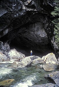
The park stretches along the Artlish River and a geological feature of the park are its karsts , caves and sinkholes . The two largest caves, Artlish River Cave and Black Hole Cave , have a length of 396 and 740 meters respectively. These two are located in the northwestern park area directly on the river or in its vicinity. The Artlish River also flows part of the way through the Artlish River Cave. In terms of flow rate and dimensions, it is currently the largest known and active river cave system in Canada. In addition to the large ones, there are also other, smaller caves in the park.
The park is surrounded by the mountains of the Haihte Range belonging to the Vancouver Island Ranges . On the eastern edge of the park is the 1521 m high Mook Peak , while the park itself rises a not quite as high, opposite mountain.
The park is a Category II protected area . ( National park )
history
The park was established in 1996 and when it was established it already had an area of 234 hectares. Over time, it was expanded to its present size.
As with almost all provincial parks in British Columbia, it is also true that long before the area was settled by immigrants or became part of a park, it was the hunting and settlement area of various First Nations tribes , in this case the Kyuquot . The name of the park also goes back to a group of the Kyuquot, the A'licath (in English: Artlish). There are also some culturally modified trees in the park .
The caves in the park were first reported in 1932 by the Canadian Geological Survey and then mapped from 1974 to 1978. Prior to 1932, the caves were known only to the resident First Nation, hunters, and loggers.
Flora and fauna
Forestry use on a larger scale also took place in the park before it was established. Therefore, there is not much primary forest here . In addition to the Sitka spruce , the West American hemlock , the giant arborvitae and the purple fir can also be found here .
The detectable animal species correspond to the location of the park. The area includes the black bear and the wapiti ( Cervus elaphus roosevelti , Roosevelt wapiti). The caves in the park also form a wintering space for various bat species. The river is home to sockeye salmon , silver salmon , king salmon , pink salmon , as well as rainbow trout and steelhead .
activities
The park has no tourist infrastructure. So-called backcountry camping is allowed, however.
For tourism, the caves are the park's attraction. There are professional guides for the caves. Due to the remoteness and the poor accessibility, the number of park visitors is limited.
You can also go canoeing on the Artlish River with professional guides.
See also
Web links
- Artlish Caves Provincial Park . In: BC Geographical Names (English)
- Artlish Caves Provincial Park . In: English language website of the park at BC Parks
- Information to the park on britishcolumbia.com (Engl.)
Individual evidence
- ↑ Mook Peak in the Internet version of the Canadian Mountain Encyclopedia
- ↑ World Database on Protected Areas - Artlish Caves Park (English)

