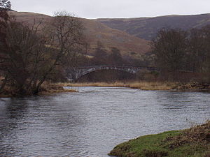
Ashiestiel Bridge
Coordinates: 55 ° 36 '22 " N , 2 ° 53' 33" W.
| Ashiestiel Bridge | ||
|---|---|---|
| Ashiestiel Bridge | ||
| use | Road bridge | |
| Convicted | Back road | |
| Subjugated | tweed | |
| place | near Ashiestiel | |
| construction | Stone arch bridge | |
| overall length | 62 m | |
| width | 5.7 m | |
| Number of openings | 1 | |
| Clear width | 40 m | |
| Clear height | 7.9 m | |
| start of building | 1847 | |
| completion | 1848 | |
| location | ||
|
|
||
The Ashiestiel Bridge , also Low Peel Bridge , is a road bridge near the Scottish town of Ashiestiel in the Council Area Scottish Borders . In 1971 the structure was included in the Scottish monument lists in the highest monument category A. With the Yair Bridge there is another listed bridge just a few kilometers downstream.
history
The bridge was planned and built from 1847 to 1848 by the company J & T Smith from nearby Darnick . Problems arose during construction, so it had to be built twice. When first erected, the arch's keystone was reportedly shot up during the removal of the falsework , causing the bridge to collapse. The company carrying out the work paid for the reconstruction. The originally set construction costs of £ 1200 could not be kept by the new building. J & T Smith went bankrupt upon completion. In the 1950s, the Ashiestiel Bridge was reinforced.
description
The 62 m long masonry viaduct spans the Tweed with just one lined segment arch . With a clear width of 40 m, the arch of the Ashiestiel Bridge is one of the world's widest arches of a quarry stone bridge . Its clear height is 7.9 m. The total width of the Ashiestiel Bridge including the border parapets is 5.7 m. The Ashiestiel Bridge leads a side road that branches off the A707 over the Tweed.
Individual evidence
- ↑ a b Listed Building - Entry . In: Historic Scotland .
- ↑ a b Entry on Ashiestiel Bridge in Canmore, the database of Historic Environment Scotland (English)
Web links
- Entry on Ashiestiel Bridge in Canmore, Historic Environment Scotland database

