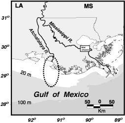
Atchafalaya River
| Atchafalaya River | ||
|
Course of the river |
||
| Data | ||
| location | Louisiana , USA | |
| River system | Mississippi River | |
| Beginning | with the branch from the Mississippi 31 ° 1 ′ 12 ″ N , 91 ° 44 ′ 53 ″ W |
|
| muzzle | at Morgan City in the Atchafalaya Bay of the Gulf of Mexico Coordinates: 29 ° 28 '46 " N , 91 ° 16' 25" W 29 ° 28 '46 " N , 91 ° 16' 25" W |
|
| Mouth height |
0 m
|
|
| length | 270 km | |
| Discharge (at branch 4,730 m³ / s) |
MQ |
6370 m³ / s |
| Right tributaries | Red River | |
| Navigable | along its entire length | |
| Longest estuary of the Mississippi | ||
|
Delta of the river |
||
The Atchafalaya River is an estuary of the Mississippi River and the former lower reaches of the Red River . It is approximately 270 km long and is located in south central Louisiana in the United States . It is navigable and is used as an industrial shipping canal for the state of Louisiana.
Emergence
The name Atchafalaya River applies from the confluence of the Red River into the canalised river branch of the Mississippi at Simmesport . The Red River once flowed here into a large loop of the Mississippi that extended westward until a Shreve's cut was built in 1831. Nevertheless, an increasing amount of water flowed over the bed of the now abandoned loop of the river to an estuary branching off the loop to the right, which in turn was marked out by the former lower course of the Red River. Instead of the old loop of the river, known as the Old River , the water now leaves the Mississippi via a parallel, 11-kilometer-long canal built in the 1960s to the west. The water flow of the canal is now held by the Old River Control Structure at around 30 percent of the Mississippi discharge, that is to say at an average of 4730 m³ / s.
course
At the end of the canalized Old River, the Red River joins from the right as the largest tributary (1590 m³ / s). The Atchafalaya meanders then diked southwards through extensive floodplains. About 25 kilometers below Morgan City it flows into the Gulf of Mexico into Atchafalaya Bay . The river here forms a new delta in the bay - the only area on Louisiana's coast where new land is naturally created.
Culture and economy
The Atchafalaya River has a special cultural meaning for the Cajun Country . Maintaining the river as the navigable arm of the Mississippi has been a major project of the United States Army Corps of Engineers for more than a century .
Name variants
The river has several designations:
- Atchafalaya River
- Atachaffalaya River
- Atchaalaya River
- Atchafalayia River
- Atchafayalia River
- Atchafaylia River
- Atchaffalay River
- Atchafylia River
- Atchapalaya River
- Bayou Atchafalaya
- Chafalia River
- Chaffalia River
- Chaffeli River
- River Atchafa-Laya
- Tchafalaya River
Individual evidence
- ↑ a b US Census 2000: Flows of Largest US Rivers - Length, Discharge, and Drainage Area (data converted and rounded to 5)
- ↑ GNIS - US Post Office Site Location Report, 1837-1950, available in microfilm, use code US-T140 / # - # of roll. roll 245
- ↑ a b c d e f g GNIS - US Post Office Site Location Report, 1837-1950, available in microfilm, use code US-T140 / # - # of roll. roll 237
- ^ Original township survey plats, published in the 1800's. 1827
- ↑ Lorio, Elaine C. The Place-Names of Pointe Coupee Parish . Baton Rouge, Louisiana: Louisiana State University Thesis, 1932. p10
- ^ A b c d Read, William Alexander Louisiana Place-Names of Indian Origin Baton Rouge, Louisiana . Louisiana State University Press, 1927. p5
- ^ Saucier, Corinne L. History of Avoyelles Parish, Louisiana . New Orleans, Louisiana: Pelican Publishing Company, 1943. p198

