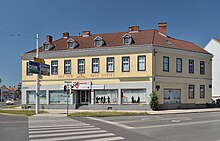
Sudetendeutscher Platz (Wiener Neustadt)
The Sudeten Place , formerly intersection Eye of God , is at a crossroads in Wiener Neustadt in Lower Austria .
location
Sudetendeutsche Platz is north of downtown Wiener Neustadt on the edge of Josephsstadt. The following roads are connected to the square:
- Wiener Straße (single lane, one-way street leading away from the Eye of God towards the city center )
- Grazer Straße ( B17 , B54 four-lane south )
- Pottendorfer Straße ( B60 , two lanes to the east )
- Wiener Straße (B17, four lanes to the north )
- Fischauer Gasse (two lanes to the west )
history
The origin of the name "Eye of God" for this crossing is controversial. The general term in Austria: “Eye of God” for a triangular intersection is not uncommon. The Eye of God is also joined by the Freedom Park between Wiener Strasse and Grazer Strasse, where the resistance monument and the rubble monument are located.
After 1945 the intersection area was dedicated as Sudetendeutscher Platz, and the Raiffeisen fountain was built in 1983 in a square-like area.
traffic
The intersection is one of the busiest intersections in Wiener Neustadt and therefore also one of the most dangerous intersections in the city.
City buses A, G, and H of Stadtwerke Wiener Neustadt as well as some regional bus routes stop at the Augen Gottes bus stop on Grazer Straße.
literature
- Sudetendeutscher Platz (Crossing Eye of God), Raiffeisen-Brunnen. Pp. 157-158. In: Gerhard Geissl: Monuments in Wiener Neustadt. Places of remembrance. Kral-Verlag, Berndorf 2013, ISBN 978-3-99024-167-7 .
Web links
Individual evidence
- ↑ Austrian quiz. Retrieved February 8, 2019 .
- ^ Resistance memorial site in Freedom Park - I. Accessed on February 8, 2019 .
- ↑ Place of remembrance of the rubble dreamer monument in the Freedom Park. Retrieved February 8, 2019 .
- ↑ The most dangerous streets in the district. Retrieved February 8, 2019 .
- ↑ Line network of the city - Wiener Neustadt. Retrieved February 8, 2019 .
Coordinates: 47 ° 49 ′ 21.3 " N , 16 ° 14 ′ 47.9" E
