Azat
| Azat | ||
|
Course of the Azat (in the pink-colored area) |
||
| Data | ||
| location | Ararat Province , Kotajk ( Armenia ) | |
| River system | Kura | |
| Drain over | Macaws → Kura → Caspian Sea | |
| source |
Gegham Mountains 40 ° 10 ′ 53 ″ N , 45 ° 0 ′ 16 ″ E |
|
| muzzle |
Ara's coordinates: 39 ° 57 ′ 38 " N , 44 ° 29 ′ 18" E 39 ° 57 ′ 38 " N , 44 ° 29 ′ 18" E
|
|
| length | 55 km | |
| Catchment area | 572 km² | |
| Drain |
MQ |
4.88 m³ / s |
| Reservoirs flowed through | Azat dam | |
| Small towns | Garni | |
|
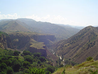
Azat below Garni |
||
|
Azat dam |
||
The Asat ( Armenian Ազատ ) is a left tributary of the Aras in the Armenian provinces of Ararat and Kotajk .
The Asat rises on the western flank of the Ashdahak , the highest mountain in the Gegham Mountains . From there it flows through the Chosrow reserve in a predominantly southwestern direction . The Geghard Monastery , located on the upper reaches of the Asat, is a UNESCO World Heritage Site . The river flows past the small town of Garni . Later it will be dammed up by the Asat dam to generate energy and for irrigation purposes. Finally the asat flows into the macaws. The Asat has a length of 55 km. It drains an area of 572 km². The mean discharge is 4.88 m³ / s.


