Yeovil Junction Railway Station

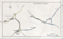
Blue: L & SWR , yellow: Great Western Railway
The Yeovil Junction railway station is the larger of the two remaining stations of the 42,000-inhabitant town Yeovil in South Somerset in England . The train station is about two kilometers from the closed development of the city on the green field . The southern border of the railway facilities has also been the border with the neighboring county of Dorset since 1995 . This year there was a border shift because the train station was previously even in the neighboring county. The station is 197 train kilometers southwest of London Waterloo .
history
As the first railway company, the Bristol and Exeter Railway (B&ER) reached the city of Yeovil in the autumn of 1853 on its west side in 2140 mm wide gauge . The Yeovil Pen Mill station was built for this purpose. In July 1860, the London and South Western Railway (L & SWR) came to Yeovil on the east-west route London - Exeter and built its standard gauge station in the south of the city directly at the intersection with the already existing north-south connection of B&ER.
A few weeks earlier, the Salisbury and Yeovil Railway (S&YR), which later - like B&ER - was bought by the Great Western Railway (GWR), had already arrived with its own line from Taunton immediately south of the city (see Fig. Scheme drawing of the historical development) and operated the Yeovil Town station . The networks of the various societies were connected to one another. Yeovil Junction, the youngest and most distant of the three train stations, became the city's interchange station.
In addition to this already quite complicated track structure, a broad gauge track of the GWR was also integrated from June 1864 to the "L & SWR" Yeovil Junction station, which was available to the traffic of the Clifton-Maybank branch further south. Mainly goods traffic between the two companies was carried out on this track. This handover became possible from mid-June 1874 when the broad gauge tracks of the GWR were converted to standard gauge.
In 1870 the L & SWR line was extended to double track . The Yeovil Junction station got two island platforms and a central through track for relocating locomotives. The platforms are connected to the main platform via a wooden pedestrian bridge. There are some sidings to the north of the platforms.
In the 1960s, as everywhere in England, a lot of railway infrastructure was dismantled; even closing Yeovil Junction has been considered. The north-south and east-west connections have been preserved to this day; the southern platform was closed for passenger traffic.
Web links
- Kent Rail with a detailed description, track plan and many photos ( Memento from February 15, 2009 in the Internet Archive )
Coordinates: 50 ° 55 ′ 29 " N , 2 ° 36 ′ 44" W.

