Lomé – Blitta railway line
| Lomé – Blitta | |||||||||||||||||||||||||||||||||||||||||||||||||||||||||||||||||||||||||||||||||||||||||||||||||||||||||||||||||||||||||||||||||||||||||||||
|---|---|---|---|---|---|---|---|---|---|---|---|---|---|---|---|---|---|---|---|---|---|---|---|---|---|---|---|---|---|---|---|---|---|---|---|---|---|---|---|---|---|---|---|---|---|---|---|---|---|---|---|---|---|---|---|---|---|---|---|---|---|---|---|---|---|---|---|---|---|---|---|---|---|---|---|---|---|---|---|---|---|---|---|---|---|---|---|---|---|---|---|---|---|---|---|---|---|---|---|---|---|---|---|---|---|---|---|---|---|---|---|---|---|---|---|---|---|---|---|---|---|---|---|---|---|---|---|---|---|---|---|---|---|---|---|---|---|---|---|---|---|
|
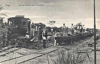
On the way to Atakpamé
| |||||||||||||||||||||||||||||||||||||||||||||||||||||||||||||||||||||||||||||||||||||||||||||||||||||||||||||||||||||||||||||||||||||||||||||
| Gauge : | 1000 mm ( meter gauge ) | ||||||||||||||||||||||||||||||||||||||||||||||||||||||||||||||||||||||||||||||||||||||||||||||||||||||||||||||||||||||||||||||||||||||||||||
| Maximum slope : | 20 ‰ | ||||||||||||||||||||||||||||||||||||||||||||||||||||||||||||||||||||||||||||||||||||||||||||||||||||||||||||||||||||||||||||||||||||||||||||
|
|||||||||||||||||||||||||||||||||||||||||||||||||||||||||||||||||||||||||||||||||||||||||||||||||||||||||||||||||||||||||||||||||||||||||||||
The Lomé – Blitta railway was the third railway line that was built in what is now Togo . It was also known as the Hinterland Railway or the Cotton Railway .
history
The railway line was built during the German colonial era from 1908 to open up growing areas for cotton . The terrain that this route had to cross was more difficult than the two previous railway constructions in Togo: Different rivers had to be crossed, which resulted in a series of lost gradients in the route and bridge construction. The 167 km long track was opened in 1913 continuously to Atakpamé .
The route uses the Lomé station as a starting point , which was originally set up for the Lomé – Aného railway line . The line branches off at km 2.7 from the Lomé – Kpalimé railway line . Construction and operation were the German colonial railway construction and operating company transferred (DKEBBG), the railway operations in Togo under "Togo Railway" (TE) was renamed and 523,000 annually Reichsmark lease to the Treasury should pay the colony. The large radio station Kamina , 12 km southeast of the city, had its own connecting line with a 600 mm gauge to Agbonou station . The intention was to extend the hinterland railway , if possible as far as Banjeli , in order to develop the red iron ore deposits there , but this did not happen due to the outbreak of the First World War .
During the period of military occupation until 1922, the web was initially under the name Togoland Military Railway operated (TMR), the rail operations in the hands of the neighboring railway in the Gold Coast , the Gold Coast Government Railways was. After World War Togo was between Great Britain and France divided the entire railway network in the part of the country, now of France as a League of Nations - mandate was managed came to rest. Only then, in 1922, did the railway receive its first French-speaking name: Chemins de fer de Togo (CFT).
The French colonial power only expanded the railway line in the 1930s. In 1934, starting in Agbonou on the Lomé – Atakpame line , a 113 km long line to Blitta was opened. The ongoing construction to Sokodé , which had already started , was discontinued due to lack of money. A connection to railway lines in French West Africa , which was considered in the 1950s, was never realized either.
The line continued to operate as the main line of the Togo railway network even after Togo's independence.
See also
literature
- Franz Baltzer : The colonial railways with a special focus on Africa . Berlin 1916; Reprint: Leipzig 2008, ISBN 978-3-8262-0233-9 . ( Preview on Google Books )
- Helmut Schroeter, Roel Ramaer: The railways in the once German protected areas. Then and now. Röhr-Verlag, Krefeld 1993, ISBN 3-88490-184-2 .
- Helmut Schroeter: The railways of the former German protected areas in Africa and their vehicles (= The vehicles of the German railways. H. 7, ZDB -ID 593887-9 ). Transport Science Teaching Aid Society, Frankfurt am Main 1961.
