Baie du Mont-Saint-Michel
| Baie du Mont-Saint-Michel | ||
|---|---|---|
|
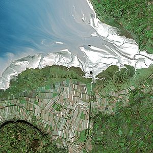
Aerial view of the bay |
||
| Waters | English Channel | |
| Land mass | Western Europe | |
| Geographical location | 48 ° 41 ′ N , 1 ° 39 ′ W | |
|
|
||
| surface | 500 km² | |
| Islands | Mont Saint-Michel , Tombelaine | |
| Tributaries | Couesnon , Sélune , Sée | |
The Baie du Mont-Saint-Michel ( German Bay of Mont-Saint-Michel ) is a sea bay in France . It lies between Brittany in the west and the Cotentin peninsula in the east (or rather Avranchin ). In the bay is the Mont-Saint-Michel , which gave it its name. Together with Mont Saint-Michel, the bay is a UNESCO World Heritage Site .
The bay extends over an area of around 500 square kilometers. In the west it begins at Cancale near Saint-Malo . In the east it extends to about Carolles south of Granville . The tidal range is particularly pronounced and is over ten meters. The most important tributaries into the bay are the Couesnon , the Sélune and the Sée .
Web links
- Mont St-Michel bay (English)

