Balranald
| Balranald | |||||||
|---|---|---|---|---|---|---|---|
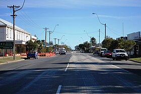
 The Sturt Highway at Balranald |
|||||||
|
|||||||
|
|||||||
|
|||||||
|
|
|||||||
Balranald is located on the Sturt Highway on the Murrumbidgee River , 553 kilometers east of Adelaide and 643 kilometers west of Canberra . 1200 inhabitants live in the town in New South Wales .
Balranald is considered the gateway to Mungo National Park , which is about 150 kilometers away. In this park, which was one of the first national parks in Australia to be listed as a World Heritage Site , geologists found the two oldest human skeletons in Australia, Mungo Man and Mungo Lady, 40,000 years old.
When the explorer Thomas Livingstone Mitchell explored the area in 1836, he reported the good quality of the soil, after which settlers settled in the area and founded Balranald as a town in 1851. The place has a reputation for having the best fishing grounds on Australia's rivers. Five rivers can be reached within a radius of about 30 kilometers. In Balranald there is an art gallery in a 120 year old Masonic Lodge and Greenham Park. At the end of October, the Balranald Outback Festival takes place every 2 years .
Balranald lives from sheep and cattle breeding, timber and mining as well as tourism.
Web links
Individual evidence
- ↑ Australian Bureau of Statistics : Balranald ( English ) In: 2016 Census QuickStats . June 27, 2017. Retrieved January 26, 2020.
