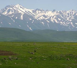
Bargushat Mountains
| Bargushat Mountains | ||
|---|---|---|
|
Aramazd, highest peak of the Bargushat Mountains |
||
| Highest peak | Aramazd ( 3399 m ) | |
| location | Syunik Province ( Armenia ) | |
| part of | Armenian highlands | |
|
|
||
| Coordinates | 39 ° 20 ′ N , 46 ° 7 ′ E | |
The Aramazd mountains ( Armenian Բարգուշատի լեռնաշղթա ; Russian Баргушатский хребет ) is located in southeastern Armenia in the province of Syunik .
The Barguschat Mountains form an eastern branch of the Sangesurkamm . It runs in a west-east direction between the rivers of Vorotan in the north and Voghji in the south. The highest point of the mountain range is the 3399 m high Aramazd . The mountain range consists mainly of sedimentary rocks of volcanic origin with intrusions of granite and granodiorite . The mountain slopes are covered by oak and hornbeam forests. Subalpine and alpine vegetation grows at higher altitudes .
The southern slopes of the Barguschat Mountains are mostly within the Sangesur reserve .
Mountains (selection)
Below are a number of peaks along the main ridge of the Barguschat Mountains, sorted from west to east:
![]() Map with all coordinates: OSM | WikiMap
Map with all coordinates: OSM | WikiMap
Web links
Topographic maps
Individual evidence
- ↑ a b c Article Bargushat Mountains in the Great Soviet Encyclopedia (BSE) , 3rd edition 1969–1978 (Russian)

