
Barrow Island Marine Management Area

The Barrow Island Marine Management Area is 114,693 hectares and extends southwest of the Montebello Islands and further south beyond the Barrow Island . This sanctuary covers all of Barrow Island except its west coast.
The management area is part of a contiguous large protected area with the Montebello Islands Marine Park with a size of 58,331 hectares and Barrow Island Marine Park with a size of 4,169 hectares, which are subject to stricter nature conservation regulations.
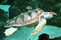
Throughout the marine protected area are green turtle , hawksbill turtle , flatback sea turtle and occasionally loggerhead turtle . Seven species of toothed whales and three baleen whales have been counted, humpback whales also stay there for a while , as do dugongs . In Barrow Iceland Marine Management Area that pierces Gorgon gas project of Chevron in search of oil and natural gas and it must be operated commercial fishing. Chevron states that there are no whale routes through the area of their drilling.

Green turtle,
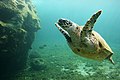
Hawksbill sea turtle
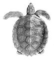
Barrier reef turtle
Loggerhead sea turtle


Web links
- rangelandswa.com.au : Roebourne Statistical Local Area with a map of the marine reserve. (PDF file; 566 kB)
Individual evidence
- ↑ ret.gov.au ( Memento of the original from February 27, 2012 in the Internet Archive ) Info: The archive link was inserted automatically and has not yet been checked. Please check the original and archive link according to the instructions and then remove this notice. (PDF; 805 kB): Gorgon Gas Development Drilling and Completion Program Environment Plan: Public Summary, in English, accessed on July 21, 2011
Coordinates: 20 ° 37 ′ 58 ″ S , 115 ° 21 ′ 43 ″ E