
Barrow Island Marine Park

The Barrow Island Marine Park , with a size of 4169 hectares , is located off the northwest coast of Western Australia , about 1,600 km from Perth and about 100 km from the city of Dampier . The sanctuary is located off the west coast of Barrow Island and is only accessible by ships or boats.
Meaning and environment
Offshore in the park is near one of Australia's most important oil and gas extraction zones , the Gorgon gas field , and it is also one of the most important breeding and nesting sites for sea turtles .
The marine park is part of a contiguous large protected area with the Montebello Islands Marine Park with a size of 58,331 hectares and Barrow Island Marine Management Area with 114,693 hectares.
The first British-Australian atomic bomb tests of 1952 took place on the nearby Montebello Islands .
Flora and fauna
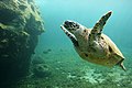
The marine park is home to endemic wall reef turtles , green turtles , hawksbill turtles and the occasional loggerhead turtle . Seven species of toothed whales and three baleen whales have been counted, humpback whales also stay there for a while , as do dugongs . There are 150 species of hard corals in the marine area and 15 species of birds have been identified. There are also significant coral reefs with tropical flora and numerous small fish in the park's waters .
Mangrove forests alternate with sandy beaches on the coast of the reserve .

Green turtle
Hawksbill sea turtle

Dugong

Humpback whale


Economic use
In the area of Montebello Islands and the Barrow Island were in 2006, natural gas and crude oil valued at AUD promoted 515 million. Settlements of mussels for pearl cultivation, the Pinctada maxima , are located in the protected area, which are exported to Japan, the USA, Hong Kong and Europe. There is also fishing, crab and turtle fishing and tourism plays a major role with diving, snorkeling, wildlife observation and water sports.
Others
Archeological traces of Aborigines have not yet been found on the coasts of this marine park.
There are no structural options on the islands.
Web links
- rangelandswa.com.au : Roebourne Statistical Local Area with a map of the marine reserve. (PDF file; 566 kB)
Individual evidence
- ^ Marineparks.wa.gov.au : Barrow Island Marine Park, in English, accessed July 19, 2011
- ^ Marineparks.wa.gov.au : Barrow Island Marine Management Area, accessed July 19, 2011
- ^ A b Management Plan for the Montebello / Barrow Islands. Marine Conservation Reserves 2007–2017. Management plan no 55 . P. 8, in English
Coordinates: 20 ° 45 ′ 38.2 " S , 115 ° 19 ′ 59.2" O