Batlama Deresi
| Batlama Deresi | ||
|
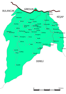
The course of the Batlama Deresi is shown as a thick gray line in the left half of the picture |
||
| Data | ||
| location | Giresun ( Turkey ) | |
| River system | Batlama Deresi | |
| Source height | approx. 1800 m | |
| muzzle | at Giresun in the Black Sea Coordinates: 40 ° 54 ′ 34 ″ N , 38 ° 21 ′ 22 ″ E 40 ° 54 ′ 34 ″ N , 38 ° 21 ′ 22 ″ E |
|
| Mouth height | 0 m | |
| Height difference | approx. 1800 m | |
| Bottom slope | approx. 45 ‰ | |
| length | 40 km | |
| Communities | İnişdibi, Çaldağ, Sayca | |
Batlama Deresi is a 40 kilometer long river in the Turkish province of Giresun that flows into the Black Sea .
The river has its source in the Pontic Mountains south of the town of İnişdibi. The Batlama Deresi flows through the central district of the province in a deep valley in a northerly direction. It passes the towns of İnişdibi, Çaldağ and Sayca before flowing into the sea about 3 km west of the provincial capital.
