Giresun
| Giresun | ||||
|
||||
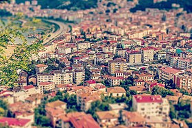
 View of the old town of Giresun (Zeytinlik) from the old fortress |
||||
| Basic data | ||||
|---|---|---|---|---|
| Province (il) : | Giresun | |||
| Coordinates : | 40 ° 55 ' N , 38 ° 23' E | |||
| Height : | 14 m | |||
| Residents : | 117,944 (2019) | |||
| Telephone code : | (+90) 454 | |||
| Postal code : | 28,000 | |||
| License plate : | 28 | |||
| Structure and administration (as of 2019) | ||||
| Structure : | 28 Mahalle | |||
| Mayor : | Aytekin Şenlikoğlu ( AKP ) | |||
| Website: | ||||
| District of Giresun | ||||
| Residents : | 138,858 (2019) | |||
| Surface: | 376 km² | |||
| Population density : | 369 inhabitants per km² | |||
Giresun (ancient Cerasus , Greek : Κερασούντα, ancient Greek : Κερασοῦς) is located in northeastern Turkey on the Black Sea , is the capital and, with over 100,000 inhabitants, the largest city in the Giresun province of the same name . At the same time it is also the center of the central district ( Merkez ).
name of the city
The origin of the name Giresun is disputed, the city was called Kerasous in antiquity ( ancient Greek Κερασοῦς ), in modern times, modern Greek Κερασούντα Kerasounta . This name probably comes either from the Greek word kerasion (κεράσιον), which means 'cherry', or from the Greek 'keras' (κέρας) for 'horn'.
geography
Giresun is located in northeastern Turkey on a horn on the Black Sea. Typical of the entire eastern Black Sea coast of Turkey are the mountain ranges and mountains of the Pontus Mountains , which extend to the coast of the Black Sea. The region is known not only in Turkey for this imposing landscape. Flat areas in the city of Giresun can only be found on the narrow coastal strip and between the two rivers and estuaries of the Batlama and Aksu . About two kilometers from the coast is the small island of Giresun Adası (Aretias). According to Greek mythology , Heracles is said to have met the Amazons there .
City structure
Despite its ancient history, Giresun is now a modern city. It is built around a mountainous peninsula. The Giresun peninsula, with Giresun Kalesi Castle at its highest point, is one of the city's landmarks and a tourist attraction. Since flat areas are rare in the urban area, many districts have been built over the years on the slopes of the mountains facing the sea. The cityscape is largely characterized by narrow and steep streets that convey their own flair. Even the newly paved main shopping and business street has a steep gradient.
The city is divided into 28 districts (Mahalle). Their population ranges from over 10,000 (Teyyaredüzü 13,733, Çıtlakkale 11,386 and Gedikkaya 1,263 inh.) To a little over 300 (Yalı 372, Cumhuriyet 359 and Samanlıkkıranı 317 inh.).
district
The central district is located in the middle of the province and has the districts ( İlçe ) Bulancak in the west, Dereli in the south and Keşap in the east as neighbors. The district is the largest in terms of population, which is probably due to the provincial capital - 83.7% of the district's population. The district has remained unchanged in its territory since Turkey was founded (1923).
Currently (at the end of 2018) it consists of Giresun, the municipality ( Belediye ) Duroğlu (3,149 inh .) And 53 villages ( Köy ) with an average of 359 inhabitants (total population of all villages: 19,010 inh .). Boztekke is the largest village with 972 inhabitants.
Climate table
The climate is humid and mild.
| Giresun (38 m) | ||||||||||||||||||||||||||||||||||||||||||||||||
|---|---|---|---|---|---|---|---|---|---|---|---|---|---|---|---|---|---|---|---|---|---|---|---|---|---|---|---|---|---|---|---|---|---|---|---|---|---|---|---|---|---|---|---|---|---|---|---|---|
| Climate diagram | ||||||||||||||||||||||||||||||||||||||||||||||||
| ||||||||||||||||||||||||||||||||||||||||||||||||
|
Average monthly temperatures and precipitation for Giresun (38 m)
|
||||||||||||||||||||||||||||||||||||||||||||||||||||||||||||||||||||||||||||||||||||||||||||||||||||||||||||||||||||||||
population
Population development
The following table shows the comparative population level at the end of the year for the province, the central district and the city of Giresun as well as the respective share at the higher administrative level. The figures are based on the address-based population register (ADNKS) introduced in 2007.
| year | province | district | city | ||
|---|---|---|---|---|---|
| real | % | real | % | real | |
| 2018 | 453.912 | 29.94 | 135.920 | 83.70 | 113,761 |
| 2017 | 437.393 | 30.85 | 134.937 | 83.31 | 112,415 |
| 2016 | 444,467 | 30.41 | 135.144 | 79.88 | 107,953 |
| 2015 | 426.686 | 30.18 | 128,779 | 83.15 | 107.075 |
| 2014 | 429.984 | 29.34 | 126.172 | 83.81 | 105,748 |
| 2013 | 425.007 | 29.21 | 124.144 | 82.41 | 102,307 |
| 2012 | 419,555 | 29.35 | 123.129 | 81.79 | 100.712 |
| 2011 | 419,498 | 29.22 | 122,597 | 82.47 | 101.107 |
| 2010 | 419.256 | 28.55 | 119,677 | 81.01 | 96,948 |
| 2009 | 421.860 | 28.25 | 119.181 | 79.68 | 94,961 |
| 2008 | 421,766 | 27.58 | 116.310 | 77.41 | 90.034 |
| 2007 | 417.505 | 27.29 | 113.936 | 78.33 | 89.241 |
Census results
The following population information about the city, the district, the province and the country is available for the censuses:
| region | 1965 | 1970 | 1975! | 1980 | 1985 | 1990 | 2000 |
|---|---|---|---|---|---|---|---|
| City (Şehir) | 25,331 | 32,522 | 38,236 | 45,690 | 55,887 | 67,604 | 83,636 |
| central circle (Merkez) | 70,323 | 77,622 | 80.103 | 86,405 | 94,746 | 102.294 | 112.501 |
| Province (İl) | 428.015 | 451,679 | 463,587 | 480,083 | 502.151 | 499.087 | 523.819 |
| Turkey | 31,391,421 | 35.605.176 | 40,347,719 | 44,736,957 | 50,664,458 | 56.473.035 | 67,803,927 |
history

Since few excavations have taken place in the region so far, not much is known about the history of the city, which was called Kerasus in ancient times . It is believed that the town of Aripša , which belonged to Azzi and was founded around 1312 BC, was located here. Was conquered by the Hittite great king Muršili II . Early finds show that the city began in the 7th century BC. Was inhabited by Greeks and ancient sources confirm that Giresun was founded by Milesians .
183 BC Chr. Was Kerasus, like Sinope , the Pontic ruler Pharnaces I. destroyed. After the reconstruction, he renamed the city Pharnakeia . In the Middle Ages Pharnakeia belonged to the Byzantine province of Armeniakon .
Osman Ağa from Giresun was Mustafa Kemal's bodyguard . In the center of Giresun there is a statue of him as a memorial and his tomb is in the castle (Giresun Kalesi) of Giresun.
economy
Fiskobirlik, one of the largest hazelnut factories in Turkey, is located in Giresun . In addition to fresh hazelnuts, she also sells nougat creams , hazelnut oils and hazelnut butter called Fındık ezmesi . Giresun is the seat of the private broadcasters Tempo TV, Mavi Karadeniz TV and Giresun TV.
Agriculture
The city has a very rich agriculture, mainly hazelnuts are grown. There is also cultivation of walnuts and cherries as well as the production of leather and timber in Giresun.
traffic
Passenger traffic takes place mainly with the Dolmuş and with other urban buses. Since it is mountainous, you have to do without trains. The port of Giresun was enlarged in the sixties. Giresun shares an airport with the city of Ordu
education
The city has urban and renowned secondary schools (Lise) and a university ( Giresun Üniversitesi ).
kitchen
The city's cuisine is typically Turkish and therefore often includes kebabs , pilaf and thick soups. In addition, a pastry called Kiymali with seasoned minced meat is very well known. Black cabbage is used a lot in the city and the surrounding area, such as B. Soups and sarma, a cabbage roll . Fresh fish and anchovies are also common in Giresun's cuisine.
Attractions
- Giresun Adası (Island of Giresun)
- Giresun Kalesi (Giresun Fortress)
- Topal Osman Anıtı (Monument to Topal Osman Ağa )
- Meryem Ana Kiliselesi ve Manastırları (Church and Monastery)
- Give Kilisesi (Church)
- Fatih Camii and Kurşunlu Cami (mosques)
- Giresun Arkeoloji Müzesi (Archaeological Museum)
- The city has several sandy beaches that can be reached by dolmuş .
Personalities
- Osman Ağa (1883–1923), actor in the First World War and the Turkish War of Independence
- Erden Alkan (* 1941), Turkish actor
- Mehmet Aygün (* approx. 1956), German-Turkish entrepreneur
- Nurettin Canikli (* 1960), Turkish politician
- Avni Kertmen (* 1961), Turkish badminton player
- Kenan Yelek (* 1975), Turkish football player
- Tolga Seyhan (* 1977), Turkish soccer player
- Cevat Yerli (* 1978), German-Turkish game developer and company founder
- Gökdeniz Karadeniz (* 1980), Turkish football player
Twin cities
photos
Web links
Individual evidence
- ↑ a b Türkiye Nüfusu İl ilçe Mahalle Köy Nüfusları , accessed on April 13, 2020
- ↑ Hans Dieter Stöver: Quintus goes to Rome, dtv junior, 24th edition (2010). ISBN 978-3-423-70118-1 , pp. 27-28.
- ↑ Central Dissemination System / Merkezi Dağıtım Sistemi (MEDAS) of the TÜIK , accessed on June 18, 2019
- ↑ Genel Nüfus Sayımları (census results 1965 to 2000) , accessed June 18, 2019
- ^ Charles Burney : Historical Dictionary of the Hittites. Rowman & Littlefield (2nd edition), Lanham 2018, p. 49.


