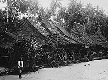
Batu Islands
| Batu Islands | ||
|---|---|---|
| Map of the Batu Islands | ||
| Waters | Indian Ocean | |
| Geographical location | 0 ° 12 ′ S , 98 ° 30 ′ E | |
|
|
||
| Number of islands | 48 | |
| Total land area | 1154 km² | |
| Residents | 10,500 | |
The Batu Islands ( Indonesian Kepulauan Batu , literally "Archipelago Rock") are an archipelago off the west coast of Sumatra in the Malay Archipelago and belong to the Indonesian province of North Sumatra .
They form the link of an island chain that stretches between 5 ° north and 4 ° south latitude from Simeulue to Enggano - in the south lies Siberut (the northernmost of the Mentawai Islands ), in the north Nias .
The Batu Islands are approximately 1,154 km² in size. In addition to the 48 smaller islets, only about twenty of which are inhabited, there are three main islands of roughly the same size:
- Pini with an area of 312.7 km² and the highest elevation of 82 m
- Tanahmasa with an area of 344.3 km² and the highest elevation of 204 m
- Tanahbala with an area of 467.6 km² and the highest elevation of 302 m
The population used to have numerous ties to Nias.
The approximately 10,500 inhabitants are mainly Malays . The administrative center is Pulautelo on the island of Telo of the same name .
The equator crosses the north of Tanahmasa and the south of Pini.
Individual evidence
- ↑ Pini. islands.unep.ch, accessed on June 18, 2015 .
- ↑ Tanahmasa. Retrieved June 18, 2015 .
- ↑ Tanahbala. Retrieved June 18, 2015 .
- ^ Batu Islands (islands, Indonesia) . britannica.com. Retrieved June 21, 2011.


