Mentawai Islands
| Mentawai Islands | |
|---|---|
| Topographic map | |
| Waters | Indian Ocean |
| Geographical location | 2 ° 11 ′ S , 99 ° 39 ′ E |
| Number of islands | 99 |
| Main island | Siberut |
| Total land area | 6,011.35 km² |
| Residents | 88,845 (2019) |
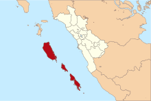
The Mentawai Islands are an island group south-west of Sumatra belonging to Indonesia . They belong to the province of Western Sumatra .
population
The inhabitants of the Mentawai Islands are among the most original peoples of Indonesia and speak their own Austronesian language. In contrast to the Minangkabau on the neighboring mainland, they were not Islamized, but adhered to animistic local religions well into the 20th century . Due to intensive missionary activities, however, a large part of the Mentawai islanders now count themselves to Christianity (approx. 80%, 2/3 Protestants and 1/3 Catholics).
geography
The archipelago is - separated by the Selat Mentawai strait - about 130 km southwest of Sumatra, covers around 6,000 km² and has 88,845 inhabitants (population update, as of 2019). The largest islands are Siberut , Sipora , North Pagai (Pagai Utara), South Pagai (Pagai Selatan) and in the south the smaller Sanding .
To the north, across the Selat Siberut strait , are the Batu Islands , to the south are Mega and Enggano .
history
After the last ice age, the islands were separated from Sumatra by rising sea levels and the resulting Mentawai Strait . From 2000 BC The ancestors of today's Mentawai inhabitants first reached the northernmost island, Siberut, and settled one after the other on the southern neighboring islands. They differ from the inhabitants of Sumatra in their language and customs.
In 1606 Siberut appeared for the first time as Mintaon on a Portuguese map, and in 1792 a ship of the British East India Company reached the Pagai Islands. It was not until July 1864 that the islands officially became part of the Dutch East Indies . In early 1899, the Mentawai Strait was explored by the German Valdivia expedition . In 1901 German missionaries set up a station on Northern Pagai. After Indonesia's independence, Catholic missionaries came from Italy. Log was felled on Siberut since the 1970s, until in 1993 half of the island was placed under protection as a national park. From the 1980s, the state promoted tourism, and from the mid-1990s, Australians discovered the islands for surfing .
administration
Since 1999 (Law No. 49/1999) the Mentawai Islands have formed a government district ( Kabupaten ) within the province of West Sumatra with the capital Tuapejat on Sipora . The administrative district was originally divided into four sub-districts ( Kecamatan ). It currently consists of ten sub-districts:
- 5 on the island of Siberut (total: 3838 km²): Siberut Barat, Siberut Utara, Siberut Tengah, Siberut Selatan and Siberut Barat Daya.
- 2 on the island of Sipora (together: 651 km²): Sipora Utara, Sipora Selatan.
- 3 on the double island of Pagai (north and south Pagai) (together: 1522 km²): Pagai Utara, Sikakap and Pagai Selatan.
nature
The islands are flat and partly covered by tropical rainforests. In addition to indigenous peoples such as the Sakhai, who still live according to their animistic traditions, the islands are also inhabited by people who have moved to Java and Sumatra. Tourism has a modest but growing importance.
The islands are home to a number of endemic animal species, including several primates such as the Kloss gibbon , Pageh snub-nosed , Pagai macaque , Siberut macaque, and Mentawai langur , as well as the Mentawai picky squirrel and the Mentawai scops owl .
Disasters
As a result of the seaquake off Sumatra in 2004, the seismic activity under the archipelago has increased significantly, so that this area can increasingly be observed as an aftershock epicenter .
As a result of a 7.7 magnitude earthquake southwest of the base of the plate , a tsunami occurred on October 26, 2010 with at least 449 dead and hundreds of injured, missing and homeless people. The early warning system introduced as a result of the 2004 tsunami worked, but the alarm came too late due to the islands' short distance from the epicenter. The day before, a tsunami alarm was triggered in Indonesia as a result of a magnitude 7.5 quake.
literature
- Henning Eichberg : Flowers in your hair are forbidden. In a Mentawi village in Indonesia . In: Under the pavement is the beach , 8 (1981) 7-41
- Wilfried Wagner (Ed.): Mentawai. Changing identity on the Indonesian outer islands. Bremen: Übersee-Museum and University of Bremen 1989
Web links
Individual evidence
- ↑ a b Kabupaten Kepalauan Mentawai Dalam Angka 2020 / Kepulauan Mentawai Regency in Figures 2020 (indon./engl.), (P. 61 of the PDF file)
- ↑ Results of the 2010 census
- ↑ - ( Memento from December 1, 2010 in the Internet Archive )
- ↑ Indonesia: Number of victims after natural disasters is increasing ( Memento from September 13, 2016 in the Internet Archive ) fr-online.de, October 31, 2010
- ^ Number of tsunami victims FAZ of October 28, 2010
- ↑ - ( Memento of November 3, 2010 in the Internet Archive )
- ↑ http://www.thejakartapost.com/news/2010/10/27/hundreds-missing-mentawai.html
- ↑ - ( Memento from October 28, 2010 in the Internet Archive )


