Northern Pagai
| Northern Pagai | ||
|---|---|---|
| Northern Pagai (North Pagai) as part of the Mentawai Islands | ||
| Waters | Indian Ocean | |
| Archipelago | Mentawai Islands | |
| Geographical location | 2 ° 42 ′ S , 100 ° 5 ′ E | |
|
|
||
| length | 40 km | |
| width | 27 km | |
| surface | 622.3 km² | |
| Highest elevation | Gunung Sabeu 336 m |
|
Northern Pagai ( Indonesian Pagai Utara ) is part of the Mentawai Islands , an island group southwest of Sumatra belonging to Indonesia .
geography
The island is 134.7 km off Sumatra, in the south is, separated by the narrow strait from Sikakap , South Pagai , in the north Sipora . The name Pageh is sometimes used for the two Pagai Islands . North Pagai is largely flat, the highest point being 336 m above sea level. The island is around 40 km long and up to 27 km wide; the area of 622.3 km² is partly covered by tropical rainforests.
administration
Northern Pagai forms (with Southern Pagai) the district ( Kecamatan ) Pagai Utara Selatan , which belongs to the administrative district ( Kabupaten ) Mentawai Islands, formed in 1999, with the capital Tua Pejat (on Sipora ), which in turn is part of the province Sumatra Barat (Western Sumatra ).
population
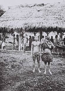
After the last ice age, the island was separated from Sumatra by rising sea levels. Before 1000 BC North Pagai was settled over the northern neighboring island of Sipora. The inhabitants differ from the inhabitants of Sumatra in terms of language and customs. In 2000, there were 20,974 inhabitants on North and South Pagai. Some settlements on northern Pagai are Pasapuat in the north, Sikakap in the southeast and Betumonga in the southwest.
history
In 1792 a British East India Company ship reached the Pagai Islands. It was not until July 1864 that North Pagai became part of the Dutch East Indies . In 1901 German missionaries set up a station on the south coast. The first missionary was killed, and it was not until 1915 that the first native converted. From the mid-1990s, Australian surfers discovered North Pagai for surfing along with the other islands . Tourism is modest but growing.
After the seaquake off Sumatra in 2004, seismic activity under the island has increased significantly. The tsunami following the earthquake on October 25, 2010 hit the island and caused a lot of damage - the village of Muntei Baru, for example, was 80% destroyed.
fauna
Several endemic animal species live on the island , including the Pagai macaque , whose population is now endangered.
Web links
Individual evidence
- ↑ a b UNEP Islands (English)
- ^ Narendra S. Bisht: Encyclopaedia of the South East Asian Ethnography. Global Vision, 2004, ISBN 9788187746966 , p. 431. Limited preview in Google Book Search
- ↑ We Couldn't Outrun Killer Wave: Villager - The Jakarta Globe. (No longer available online.) In: thejakartaglobe.com. October 28, 2010, archived from the original on October 30, 2010 ; accessed on December 30, 2014 . Info: The archive link was inserted automatically and has not yet been checked. Please check the original and archive link according to the instructions and then remove this notice.
- ^ Siberut National Park In: indonesiatraveling.com


