Baumgartenhöhe
| Baumgartenhöhe | ||
|---|---|---|
|
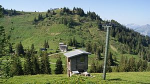
the Baumgartenhöhe with the mountain station of the cable car |
||
| height | 1646 m above sea level A. | |
| location | Vorarlberg , Austria | |
| Mountains | Winter shrub ridge , Bregenz Forest Mountains | |
| Coordinates | 47 ° 23 '54 " N , 9 ° 55' 51" E | |
|
|
||
|
the Baumgartenhöhe as a popular starting point for paragliders |
||
The Baumgartenhöhe (also Baumgartnerhöhe or Baumgartner Höhe ) is the 1646 meter high local mountain of Andelsbuch in the Austrian state of Vorarlberg . The hill is part of the winter shrub ridge in the Bregenz Forest Mountains .
Tourist development
The mountain is accessible to tourists from Bezau by a cable car ( Bezau cable car ) with an intermediate exit in Oberbezau (Sonderdach middle station). The summit is easily accessible from the mountain station, and when the visibility is good, it offers a panoramic view of the Säntis .
Surname
The Baumgartenalpe, after which the mountain is named, is located directly below the mountain summit.
Web links
Commons : Baumgartenhöhe - collection of images, videos and audio files


