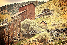
Bayhorse
| Bayhorse | ||
|---|---|---|
| National Register of Historic Places | ||
|
Abandoned day facilities of the Ramshorn Mine in Bayhorse |
||
|
|
||
| location | Custer County, Idaho | |
| Coordinates | 44 ° 23 '52 " N , 114 ° 18' 42" W | |
| surface | 64.75 ha | |
| NRHP number | 76000671 | |
| The NRHP added | 1976 | |
Bayhorse is a ghost settlement on Bayhorse Creek in Custer County , Idaho . In the narrow, deeply cut valley of the river with its side valleys, silver was mined in the late 19th century .
Bayhorse Creek is a tributary of the Salmon River about 10 kilometers long and has its source at Bayhorse Lake and Little Bayhorse Lake .
In March 1877 a silver lead galena deposit was discovered in the area, as a result the town of Bayhorse and the first mines emerged . In 1880 about 75 people lived in Bayhorse, five years later there were already 200. Smelting furnaces and a sawmill were also built in the settlement, a total of five mines ( Post Boy , Utah Boy , River View , Beardsley and Ramshorn ) produced ore for 450 ounces of silver per month. In 1885 there were three shops, five saloons , a hotel , a hostel, a restaurant and a butcher shop in Bayhorse in addition to several residential buildings . In 1889 almost 400 people lived in the village, which is how the place reached its zenith. When the Treasury Secretary William Windom lifted import restrictions on silver-lead gloss from Mexico in November 1889, the Bayhorse operation suddenly became unprofitable. The city was almost deserted within two weeks.
The settlement is relatively well preserved and is now a tourist attraction. In 2006, much of Bayhorse became part of the Land of Yankee Fork State Park and is open to the public .
Old coal pile in Bayhorse
Individual evidence
- ^ Bayhorse, Idaho - Silver in the Yankee Fork Mining District. In: Legends of America. Retrieved June 29, 2020 .


