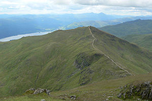
Beinn Ghlas
| Beinn Ghlas | ||
|---|---|---|
|
The Beinn Ghlas from rising to the northeast neighboring Ben Lawers seen from |
||
| height | 1103 m ASL | |
| location | Highlands , Scotland | |
| Notch height | 105 m | |
| Coordinates | 56 ° 32 '10 " N , 4 ° 14' 13" W | |
|
|
||
| rock | Mica slate | |
The Beinn Ghlas is a 1103 meter high mountain in Scotland . Its Gaelic name means greenish-gray hill and thus picks up on the color of the mica slate from which the mountain is made. The mountain, classified as Munro , is part of the mountain range lying on the north bank of Loch Tay in Perthshire , the highest peak of which is Ben Lawers , neighboring the Beinn Ghlas to the northeast . A total of seven peaks of the mountain range are classified as Munro.
Under the mountains of the Ben Lawers group, the Beinn Ghlas is a rather inconspicuous pre-summit of the Ben Lawers, which is located in front of it to the southwest and is only separated from the main summit by a relatively flat notch. Apart from a few rocky areas in the north and south-west, the Beinn Ghlas has mostly gently sloping grass slopes on all sides, which have a rare arctic flora , especially in the south . Like Ben Lawers, the mountain belongs to the National Trust for Scotland , the entire mountain range is designated as a National Nature Reserve .
Although the Beinn Ghlas is little known, it is not only climbed very often by Munro excavators , but also by many other mountain hikers. Most mountain hikers pass the summit in the course of climbing the approximately one hundred meters higher Ben Lawers. The approach leads from the National Trust visitor center to the west of Ben Lawers on the narrow road connecting Loch Tay and Glen Lyon via a wide, partly heavily eroded mountain path over the south-west ridge of the Beinn Ghlas to the summit. The continuation to Ben Lawers leads over the wide ridge between the two peaks. Another mountain path crosses the northern slopes of the Beinn Ghlas, which is used a lot, especially on the way back from Ben Lawers, in order to avoid the repeated ascent on the Beinn Ghlas.
Individual evidence
- ↑ Munro tables of the Scottish Mountaineering Club (SMC)
- ^ National Trust for Scotland: Ben Lawers National Nature Reserve , accessed September 10, 2018
Web links
- The Beinn Ghlas on walkhighlands.co.uk (English)
- The Beinn Ghlas on munromagic.com (English)


