
Belém (Paraíba)

Belém , officially Município de Belém , is a city in the Brazilian state of Paraíba . In 2006, there were 17,315 people per 100 km² in Belém.
location
Belém is in the east of the country. It is 30 km to the border with the state of Rio Grande do Norte in the north near Nova Cruz . The Atlantic coast is 65 km to the east. After João Pessoa , the capital of the state in the southeast is 90 km and km to the south Guarabira 18, each in a straight line measured. The PB-105 road runs 4 kilometers south and the PB-099 road 5 kilometers east .
history
When some houses were built around the Church of Our Lady of the Immaculate Conception in 1871 , the place was called Gengibre (ginger) because ginger was grown and traded in the area . At the beginning of the twentieth century, Capuchin missionaries came to the meanwhile grown village, who tried to change the aggressive behavior of the residents with a milder place name because of the many fights among the residents . This is how the name Belém (= Bethlehem, = "House of Bread") came about.
Visual impressions
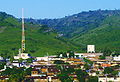
Transmission mast in Belém

City prefecture

school

Church of Our Lady

Belém


Web links
Individual evidence
- ↑ História - Prefeitura Municipal de Belém. In: gov.br. www.belem.pb.gov.br, accessed January 16, 2018 (Brazilian Portuguese).
Coordinates: 6 ° 42 ′ S , 35 ° 32 ′ W