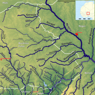
Béli
| Béli | ||
|
East Burkina Faso with the Béli (above) |
||
| Data | ||
| location | West Africa Mali Burkina Faso Niger |
|
| River system | Niger | |
| Drain over | Gorouol → Niger → Atlantic | |
| source | in southeast Mali | |
| muzzle | at Yatakala in the Gorouol coordinates: 14 ° 47 ′ 58 ″ N , 0 ° 22 ′ 37 ″ E 14 ° 47 ′ 58 ″ N , 0 ° 22 ′ 37 ″ E |
|
| Mouth height |
241 m
|
|
| length | approx. 140 km | |
|
View of the Béli near Fadar-Fadar, Burkina Faso |
||
The Béli ( pronunciation : [ beˈliː ]) is a river in West Africa.
course
The river has its source in Mali and flows through Burkina Faso and Niger . It is around 140 kilometers long and only carries water for around four to six months a year. During this time, however, it is very important for the local population and the livestock industry. The settlements of Fadar-Fadar and Tin-Akoff are on the banks of the Béli .
In some sources the Béli is also referred to as the main river and the Gorouol as its tributary.

