Belk, Alabama
|
|
This article was on the basis of substantive defects quality assurance side of the project USA entered. Help bring the quality of this article to an acceptable level and take part in the discussion ! A closer description on the resolving issues is missing. |
| Belk | |
|---|---|
|
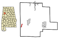
Location in the state and county
|
|
| Basic data | |
| State : | United States |
| State : | Alabama |
| County : | Fayette County |
| Coordinates : | 33 ° 39 ′ N , 87 ° 56 ′ W |
| Time zone : | Central ( UTC − 6 / −5 ) |
| Residents : | 215 (as of 2010) |
| Population density : | 63.2 inhabitants per km 2 |
| Area : | 3.4 km 2 (approx. 1 mi 2 ) of which 3.4 km 2 (approx. 1 mi 2 ) are land |
| Height : | 96 m |
| Postal code : | 35545 |
| Area code : | +1 205 |
| FIPS : | 01-05164 |
| GNIS ID : | 0113846 |
Belk is a city in Fayette County in the US state of Alabama . According to the 2000 census, Belk had 214 inhabitants, compared to 215 in 2010. Belk has a total area of 3.4 km².
geography
Belk is located in northwest Alabama in the southern United States. It is about 30 kilometers east of the Mississippi border and is located directly on Luxapallila Creek .
Nearby locations include Kennedy (5 km southwest), Fayette (6 km east), Millport (12 km southwest), Vernon (18 km northwest), and Berry (26 km east). The next larger city is Birmingham, about 95 kilometers to the east, with 212,000 inhabitants .
history
Belk was founded in 1887 as a station on the Elyton and Aberdeen Railroad . The town's first name was Mulberry Tank Junction , and when the post office opened in 1901, it was changed to its current name.
traffic
From south to north Belk is crossed by Alabama State Route 96 , which connects to US Highway 43 a few kilometers east .
Fayette City Airport, Richard Arthur Field, is approximately 10 kilometers to the northeast .
Demographics
According to the 2000 census , Belk had 214 residents, spread across 97 households and 70 families. The population density was 62.1 inhabitants / km². 97.2% of the population were white, 0.93% African American. Children under the age of 18 lived in 23.7% of households. The median income was $ 32,188 per household, with 6.3% of the population living below the poverty line .
By the 2010 census , the population rose slightly to 215.
Web links
- Statistical data on Belk (Engl.)
- Belk in the Encyclopedia of Alabama (Engl.)

