
Bental
| Bental
Jebel al-Gharam
|
||
|---|---|---|
 The mountain range of the Bental |
||
| height | 1171 m | |
| location | Al-Quneitra Governorate ( Syria ), de facto z. T. Northern District (Israel) | |
| Mountains | Golan Heights | |
| Coordinates | 33 ° 7 '41 " N , 35 ° 47' 8" E | |
|
||
| Type | Welding slag cone | |

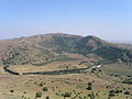
The Bental ( Arabic جبل الغرام, DMG Ǧabal al-Ġarām 'Mountain of Lust' orجبل بنطل / Ǧabal Banṭal ; Hebrew הר בנטל Har Bental, "Berg Bental") is an extinct volcano in the northeast of the Golan Heights . It has a pronounced crater and lies north of the 1204-meter-high Avital , with which it shares an underground magma chamber . Both volcanoes are part of a series of extinct volcanoes that stretch from Mount Ram at 1,188 meters to the Saki Valley at 594 meters on the eastern side of the Golan Heights. The crater of the Bental was torn open in a westerly direction by a lava flow that also carried away the ashes of a volcanic cone. The rest of the volcano is only 1171 meters high. A special flora and fauna have developed on the volcanic soil, so that this area is now a protected area.
Part of the - currently still controversial - border between Israel and Syria runs over the mountain . At the north-west opening of the crater, the kibbutz Merom Golan was founded in 1967 after the Six Day War .
gallery

Hut on the summit

Hut and fortifications

Fortifications
Avital (left), Bental (right)

View of Quneitra


.jpg)

