
Berghof (Vienna)
In the area of the Roman Vindobona a remaining settlement was built, in the center of which there was a building that was known as the Berghof or Alter Berghof from the 13th century at the latest . It is considered to be the nucleus of what would later become Vienna . The Berghof was located in the area of the Hoher Markt - Marc-Aurel-Strasse - Sterngasse - Judengasse, in the immediate vicinity of the Ruprechtskirche .
The name possibly means that it was a farm for viticulture (from the vineyards).
Around the year 1280 the complex with the name "Berghof" is mentioned in the prince book of Jans dem Enikel . The prince book refers to the 11th century. According to the Prince's Book, the place is said to have been pagan back then .
The Kienmarkt, Vienna's first medieval market, was located between Berghof and Ruprechtskirche. In the early Middle Ages , trade was also carried out in the church, sometimes even in the cemetery.
The area was poorly developed archeologically when the houses at Sterngasse 5 and 7 were demolished in 1962, where the remains of a bath from Roman times were secured (several ashlar stones of this bath are exhibited in Sterngasse). Traces of settlement from the early Middle Ages were found, but no buildings older than the 13th century.

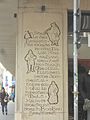
Inscriptions on the

House Hoher Markt 8–9,

to the Berghof
Referring to


Web links
- Alter Berghof in the Vienna History Wiki of the City of Vienna
- History of the Berghof on the homepage of the Austrian Academy of Sciences
- Berghof - the nucleus of Vienna (private homepage kmu-center.at)
- Fake news about the beginning of Vienna? on derstandard.at
Pictures from the Berghof
- Plan: The Kienmarkt in its different phases (with Berghof) on hfi.uni-graz.at
- The last two Gothic houses of the Berghof (Sterngasse 5), which were demolished from 1962. Direction Marc Aurelstraße (1902) and from Marc Aurelstraße towards Judengasse (1907) on bildarchivaustria.at
Coordinates: 48 ° 12 ′ 43 ″ N , 16 ° 22 ′ 22 ″ E